Prescribed burns (hazard reduction burns)
A prescribed burn is controlled burning mostly done in the cooler months to reduce fuel build up and slow the path of a summer bush fire. Prescribed burns are conducted when weather and site conditions fall within a pre-determined range, also known as a prescription.
Temperature, relative humidity, wind speed and rainfall are all considered – if it’s too hot, too windy or the bushland is too dry, it can create a high fire danger which means it could be unsafe to conduct the burn. If it’s too moist, the burn won’t be successful.
Prescribed burns are one of a number of tools used to reduce bush fire risk including clearing of asset protection zones adjacent to properties and regular fire trail maintenance.
Planned prescribed burns for 2024/25
Northern Beaches Council works with the Bush Fire Management Committee (BFMC) to develop an annual prescribed burn program. Fire agencies including Fire and Rescue NSW, the NSW Rural Fire Service and the NSW National Parks and Wildlife Service then plan and carry out the strategic prescribed burns.
The burns listed below are those planned by Council and the BFMC that include Council land. Other burns may be planned by the BFMC, fire agencies and land managers but are only listed if they include Council bushland.
Proposed burns - pending weather conditions
| BURN | LOCATION | MAP | SIZE (HA) | BUSH FIRE RISK RATING | LEAD AGENCY | STATUS |
|---|---|---|---|---|---|---|
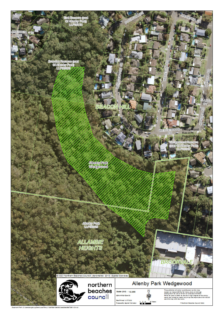
| Allenby Park Wedgewood | Allenby Park, rear of Wedgewood Crescent, Beacon Hill | View | 2.6 | Extreme | Fire & Rescue NSW | Ready |
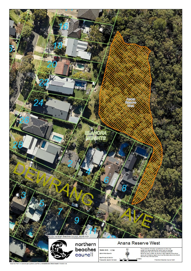
| Anana Reserve West | Anana Reserve, Elanora Road, Elanora Heights | View | 0.3 | Medium | Fire & Rescue NSW | Ready |
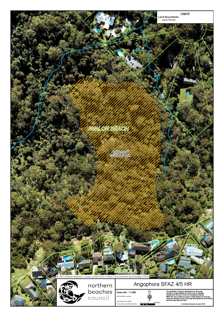
| Angophora – SFAZ 4/5 | Angophora Reserve, 93 Palmgrove Road, Avalon Beach | View | 1.3 | Extreme | Fire & Rescue NSW | Being prepared |
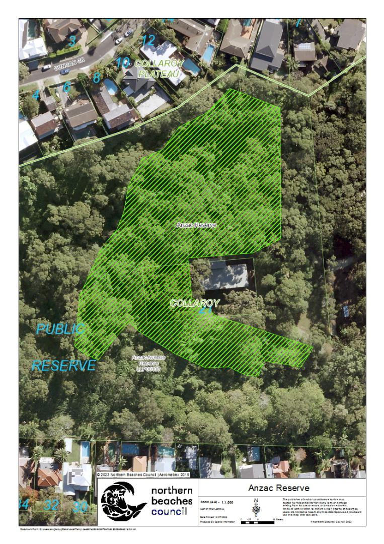
| Anzac Reserve | Anzac Reserve, Anzac Avenue, Collaroy | View | 1.8 | Very high | Fire & Rescue NSW | Ready |
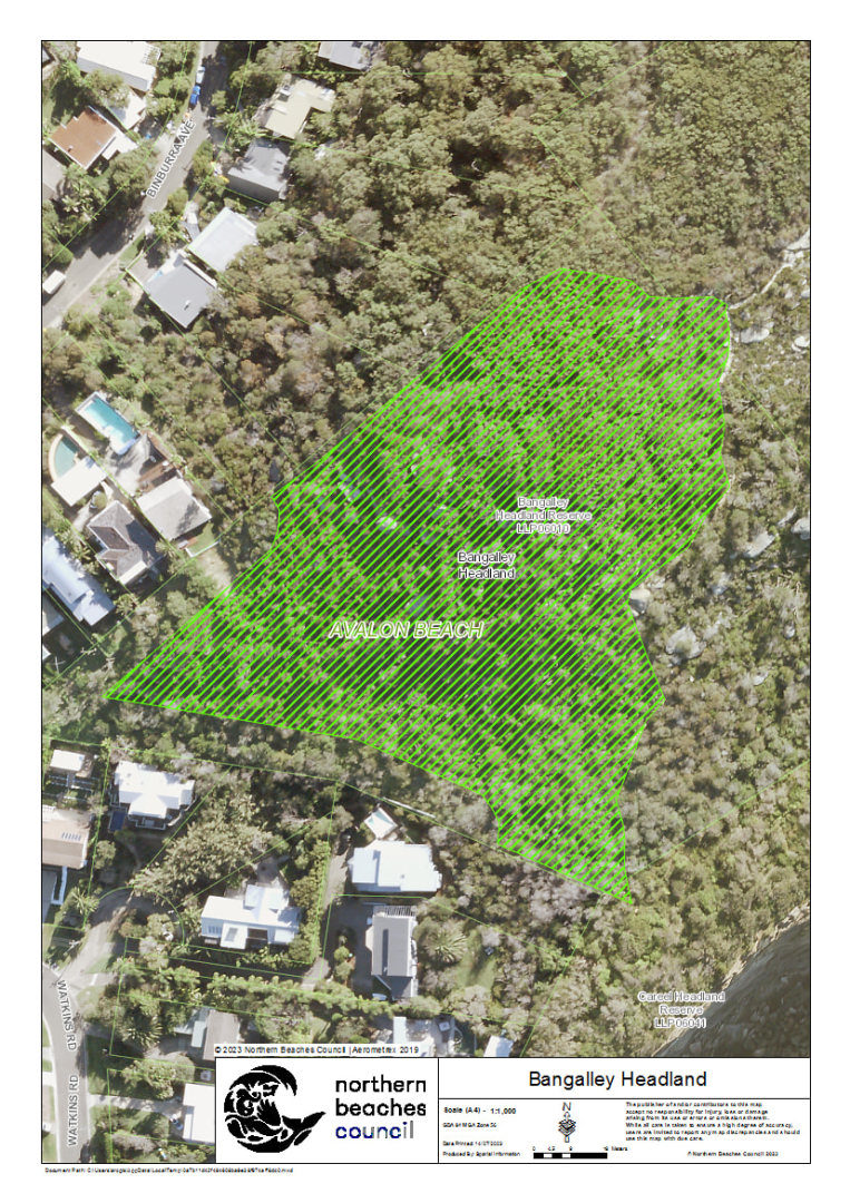
| Bangalley Headland | Bangalley Headland Reserve, Whale Beach Road, Avalon Beach | View | 1.2 | High | Fire & Rescue NSW | Ready |
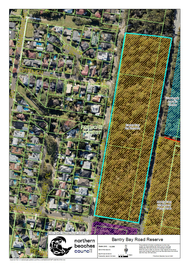
| Bantry Bay Road Reserve | Bantry Bay Road Reserve, Bantry Bay Road, Frenchs Forest | View | 4.2 | Extreme | NSW Rural Fire Service | Ready |
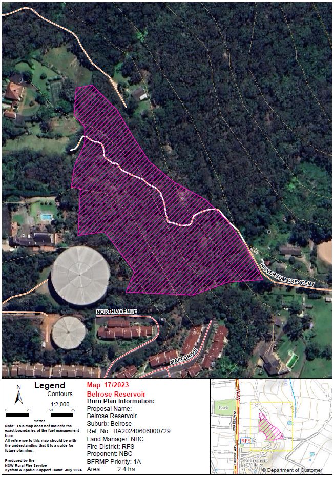
| Belrose Reservoir | Hilversum Crescent, Belrose | View | 2.9 | Extreme | NSW Rural Fire Service | Being prepared |
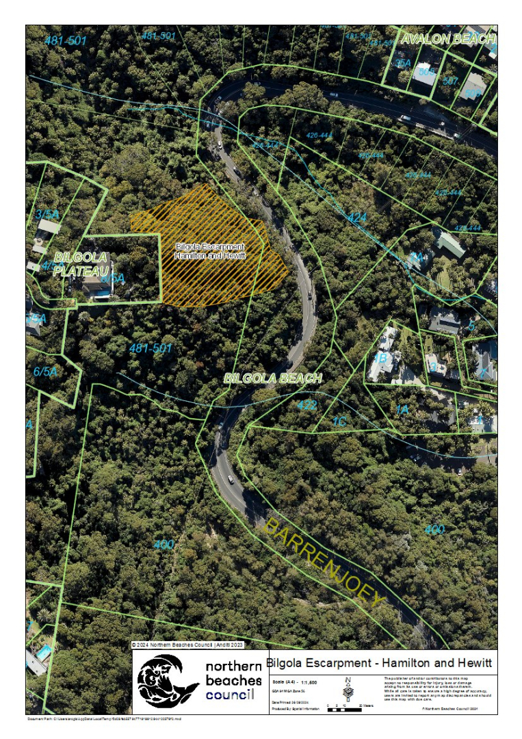
| Bilgola Escarpment - Hamilton and Hewitt | Hewit Park And Hamilton Reserve, 481-501 Barrenjoey Road, Bilgola Beach | View | 0.4 | Extreme | Fire & Rescue NSW | Ready |
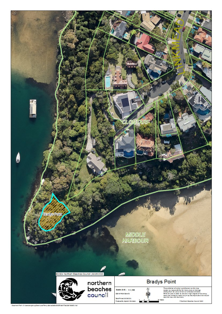
| Bradys Point | Sandy Bay Road, Clontarf | View | 0.06 | Medium | Fire & Rescue NSW | Ready |
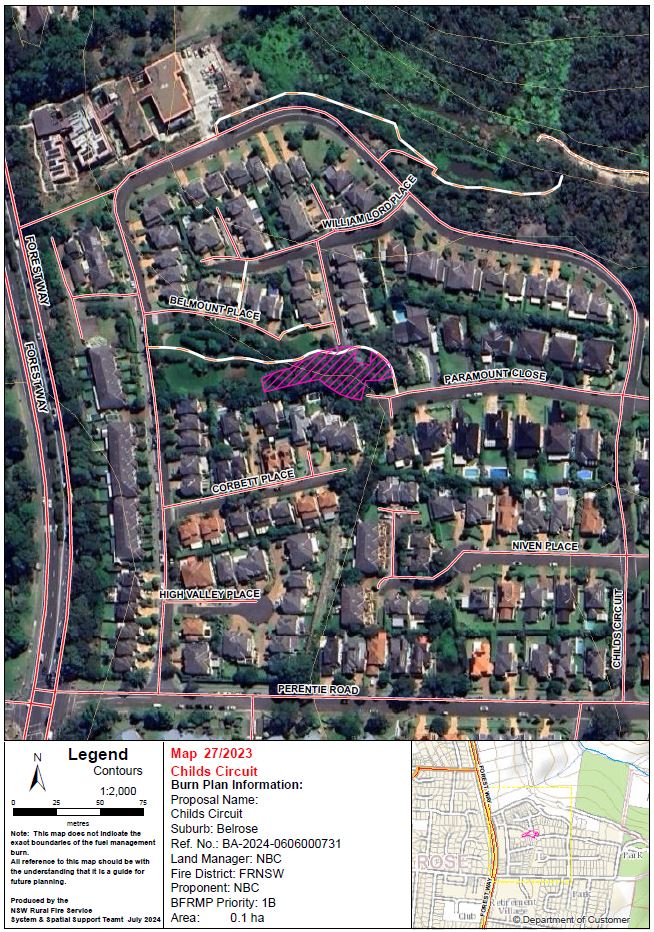
| Childs Circuit Reserve | Childs Circuit Reserve, Childs Circuit, Belrose | View | 0.1 | Extreme | Fire & Rescue NSW | Being prepared |
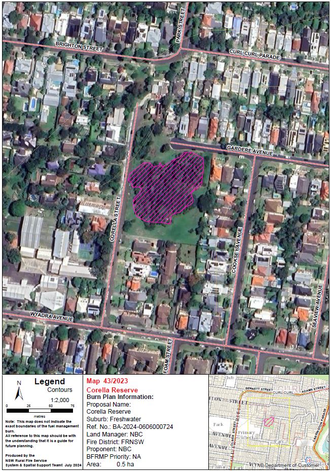
| Corella Reserve | Corella Reserve, Corella Street, Freshwater | View | 0.5 | N/A | Fire & Rescue NSW | Being prepared |
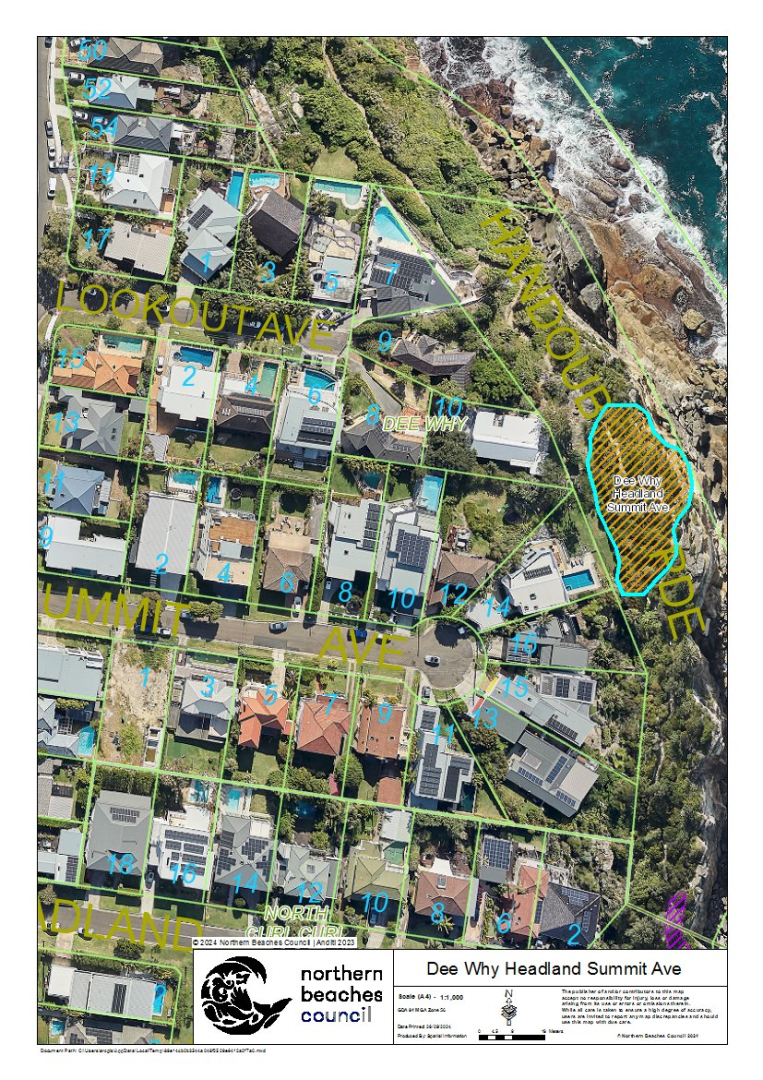
| Dee Why Headland Summit Ave | Dee Why Lagoon Wildlife Refuge, rear of Summit Avenue, Dee Why | View | 0.1 | Medium | Fire & Rescue NSW | Ready |
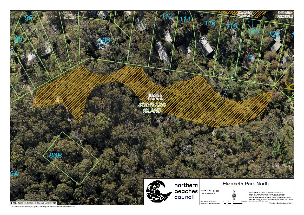
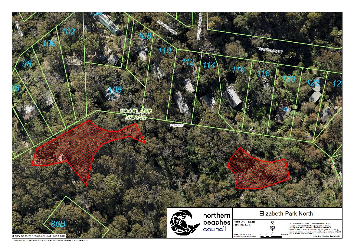
| Elizabeth Park North | Elizabeth Park, Thompson Street, Scotland Island | View | 0.3 | Extreme | NSW Rural Fire Service | Ready |
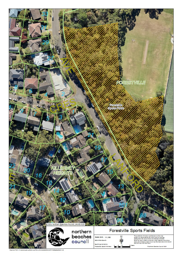
| Forestville Sports Fields | Forestville Playing Fields, Melwood Avenue, Forestville | View | 1.2 | Medium | Fire & Rescue NSW | Ready |
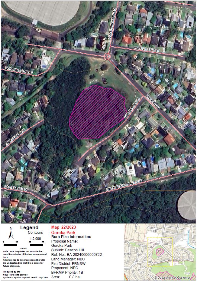
| Goroka Park | Goroka Park, Goroka Place, Beacon Hill | View | 0.8 | Extreme | Fire & Rescue NSW | Being prepared |
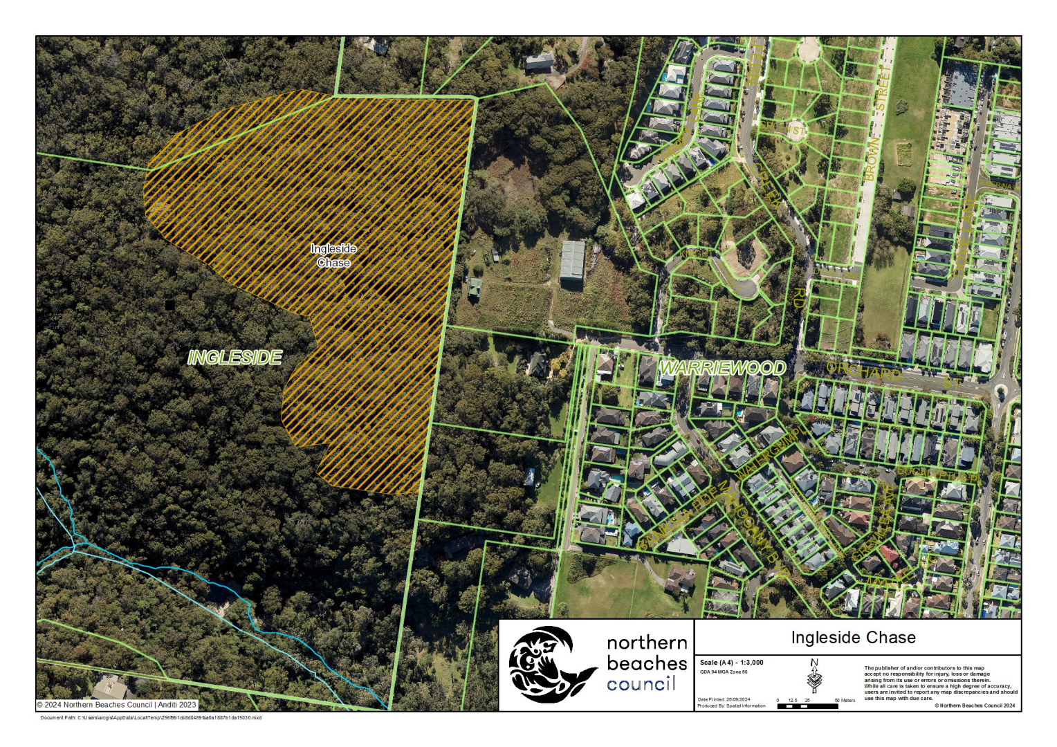
| Ingleside Chase | Ingleside Chase Reserve, Ingleside Road, Ingleside | View | 5.8 | Medium | NSW Rural Fire Service | Ready |
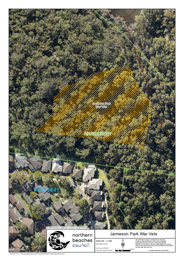
| Jamieson Park War Vets | Jamieson Park, The Esplanade, Narrabeen | View | 1.1 | Extreme | Fire & Rescue NSW | Ready |
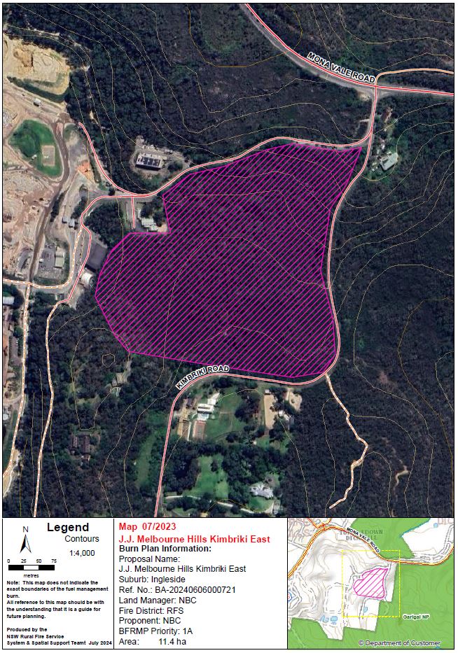
| J.J. Melbourne Hills Kimbriki East | Adjacent to Kimbriki Road and Mona Vale Road, Ingleside | View | 11.6 | Extreme | NSW Rural Fire Service | Being prepared |
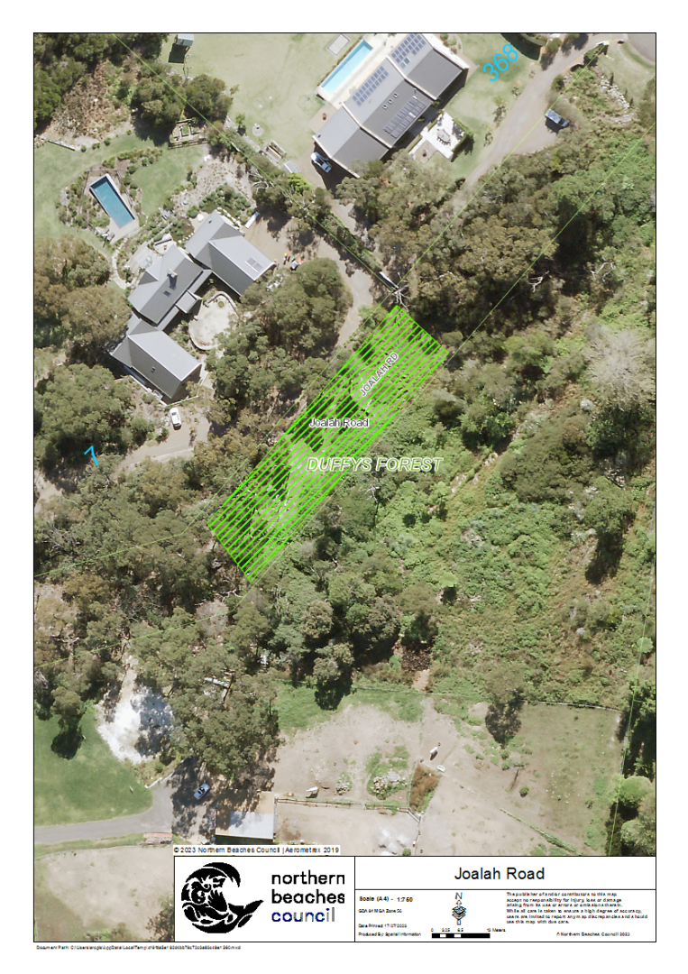
| Joalah Road | Joalah Road, Duffys Forest | View | 0.1 | Extreme | NSW Rural Fire Service | Ready |
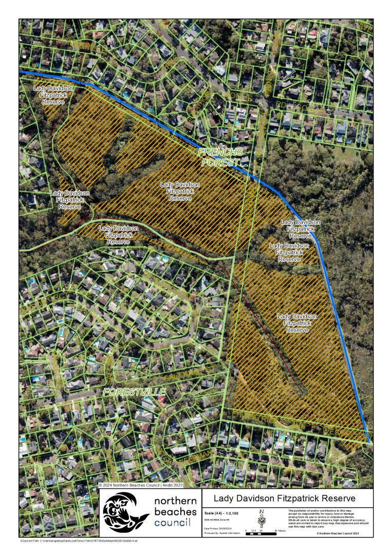
| Lady Davidson Fitzpatrick Reserve | Lady Davidson Reserve, Lady Davidson Circuit and Fitzpatrick Avenue Reserve, Fitzpatrick Avenue West, Frenchs Forest | View | 9.8 | Extreme | NSW Rural Fire Service | Being prepared |
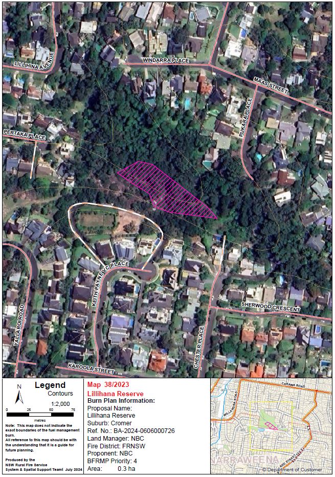
| Lillihina Reserve | Lillihina Reserve, Cromer | View | 0.3 | Medium | Fire & Rescue NSW | Being prepared |
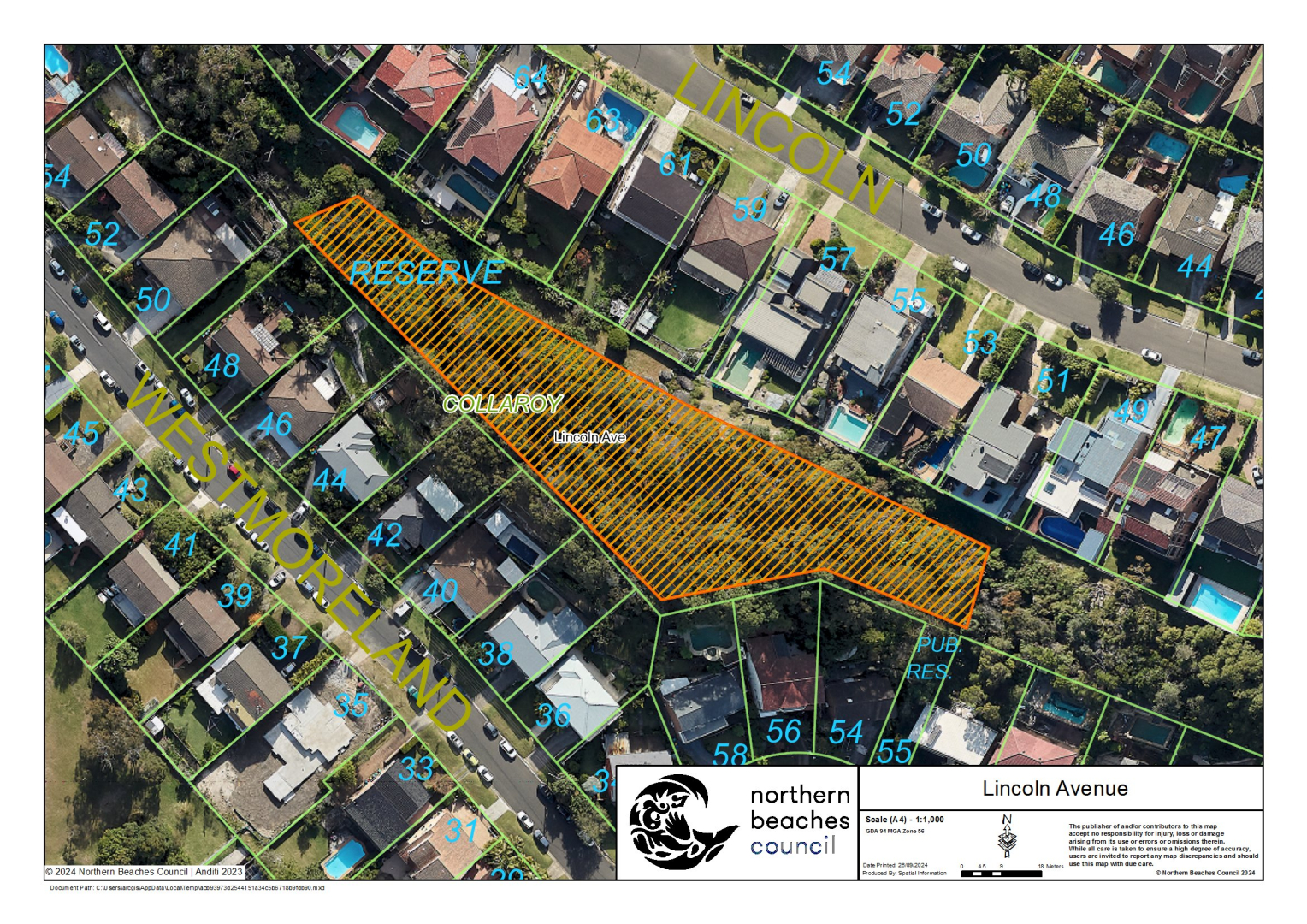
| Lincoln Avenue | Lincoln Avenue Reserve, Lincoln Avenue, Collaroy | View | 0.4 | Medium | Fire & Rescue NSW | Ready |
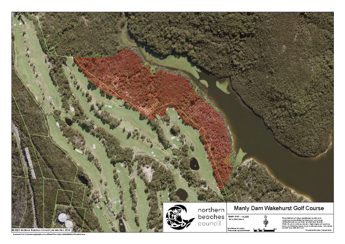
| Manly Dam Wakehurst Golf Course | Manly Warringah War Memorial Park, rear of Wakehurst Golf Course, Upper Clontarf Street, North Balgowlah | View | 9.5 | Extreme | NSW Rural Fire Service | Ready |
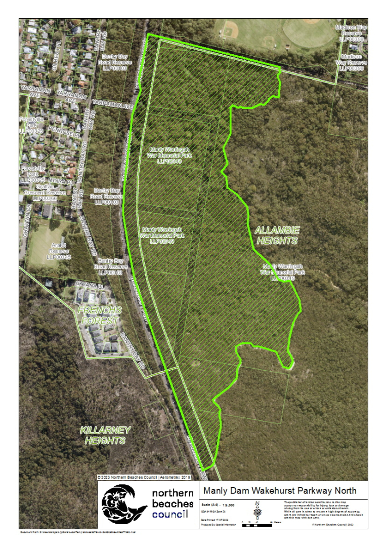
| Manly Dam Wakehurst Pkwy North | Manly Warringah War Memorial Park, Wakehurst Parkway, Allambie Heights | View | 32 | Extreme | NSW Rural Fire Service | Ready |
| Manly Dam William Charlton | Manly Warringah War Memorial Park, rear of 181 Allambie Road, Allambie Heights | View | 1.3 | Extreme | NSW Rural Fire Service | Ready |
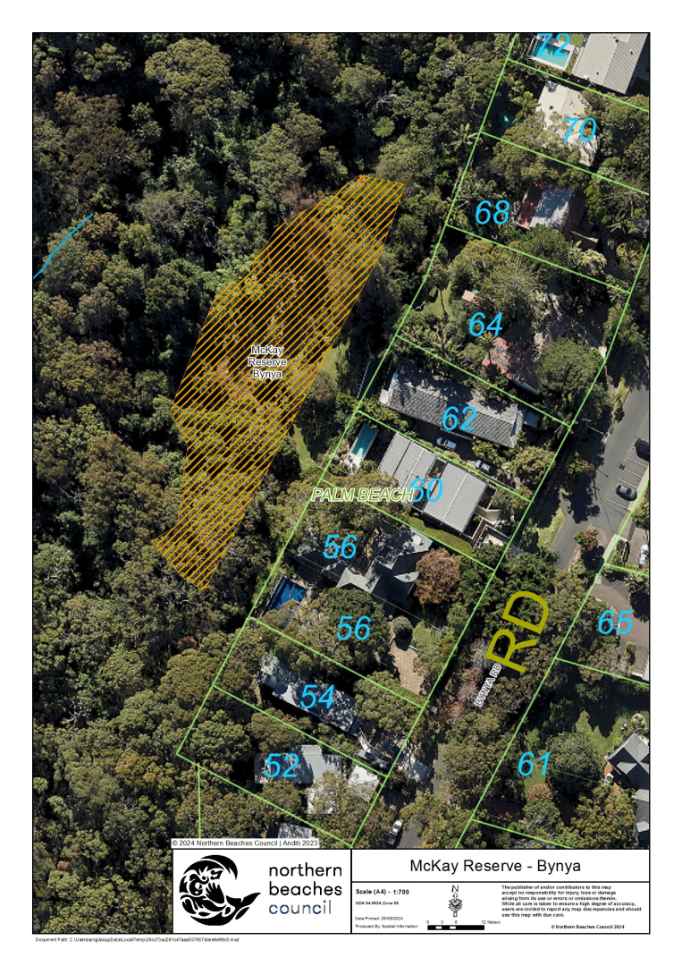
| McKay Reserve - Bynya | Mckay Reserve, McKay Road, Palm Beach | View | 0.2 | Extreme | Fire & Rescue NSW | Ready |
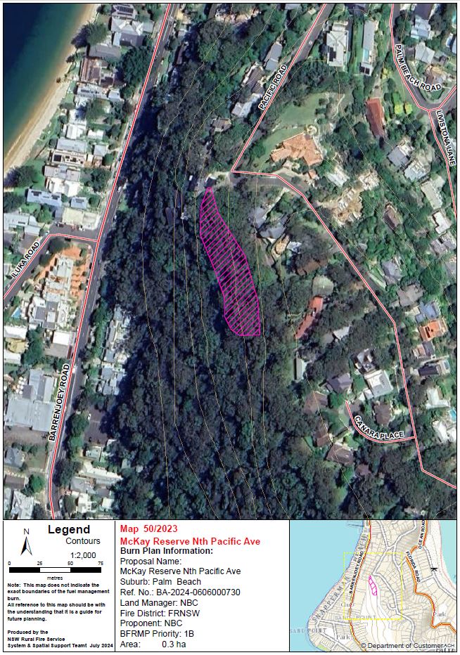
| McKay Reserve, North Pacific Ave | Mckay Reserve between Barrenjoey Road and Pacific Road, Palm Beach | View | 0.3 | Extreme | Fire & Rescue NSW | Ready |
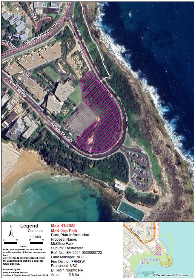
| McKillop Park | McKillop Park, Evans Street, Freshwater | View | 0.7 | N/A | Fire & Rescue NSW | Being prepared |
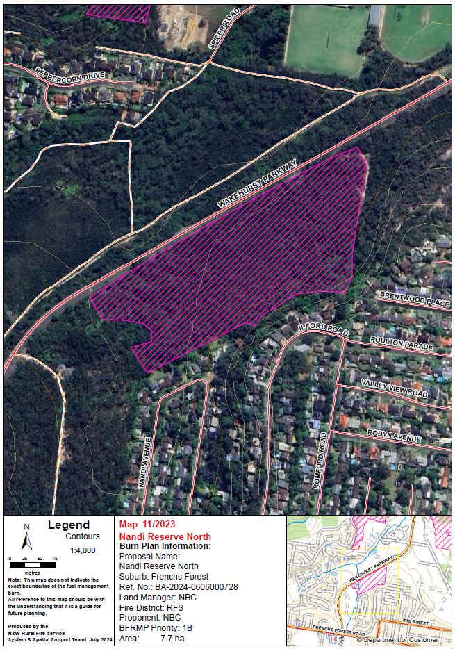
| Nandi Reserve North | Between Wakehurst Parkway, Nandi Avenue, and Ilford Road, Frenchs Forest | View | 9.5 | Extreme | NSW Rural Fire Service | Being prepared |
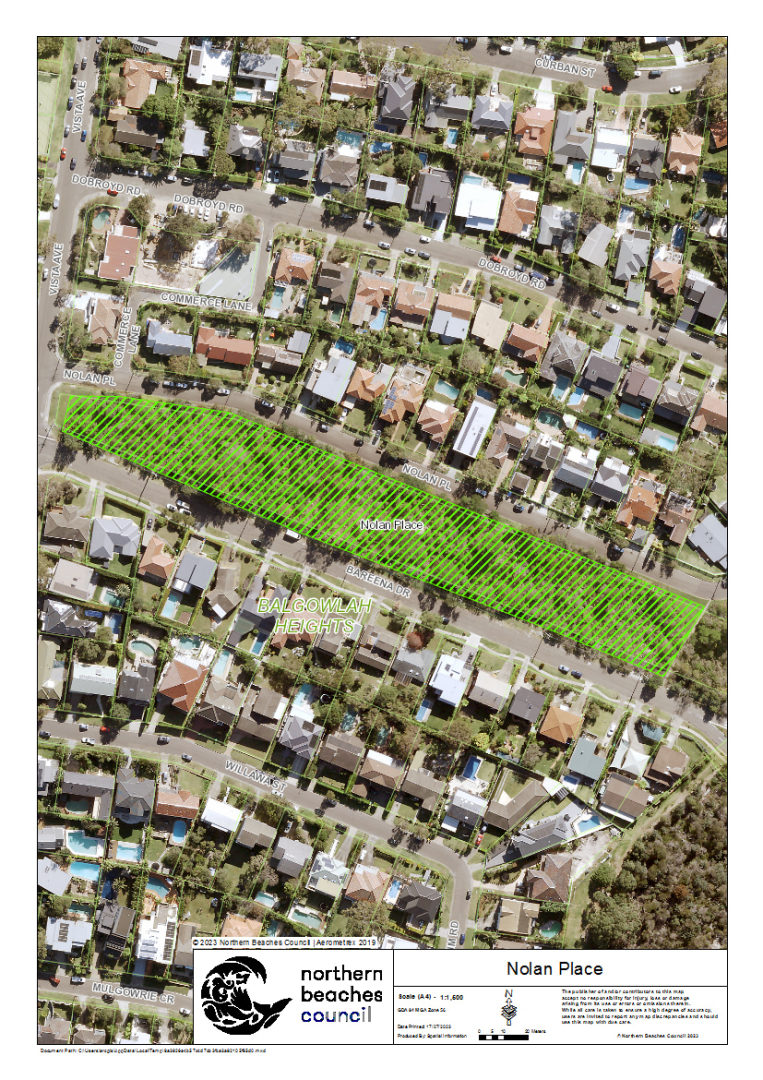
| Nolan Place | Nolan Place Reserve, Nolan Place, Balgowlah Heights | View | 0.9 | Medium | Fire & Rescue NSW | Ready |
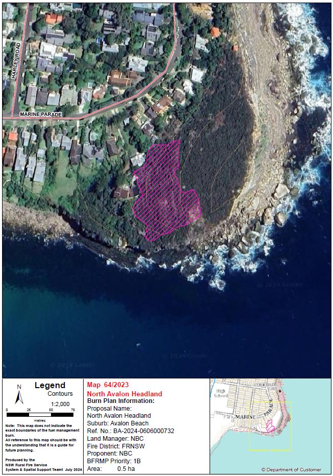
| North Avalon Headland | North Avalon Headland, Avalon Beach | View | 0.5 | High | Fire & Rescue NSW | Being prepared |
| Red Hill Reserve South | Red Hill Reserve, Guardian Parade, Beacon Hill | View | 1.0 | Extreme | NSW Rural Fire Service | Being prepared |
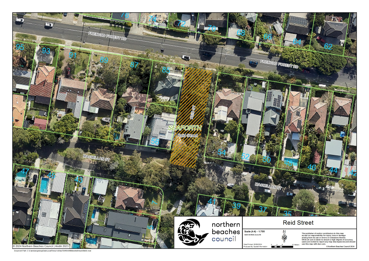
| Reid Street | Reid Street, Seaforth | View | 0.08 | N/A | Fire & Rescue NSW | Ready |
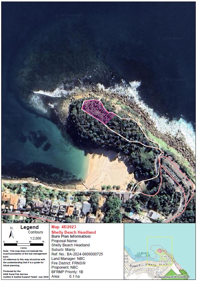
| Shelly Beach Headland North | Shelly Beach Headland, Manly | View | 0.2 | Extreme | Fire & Rescue NSW | Being prepared |
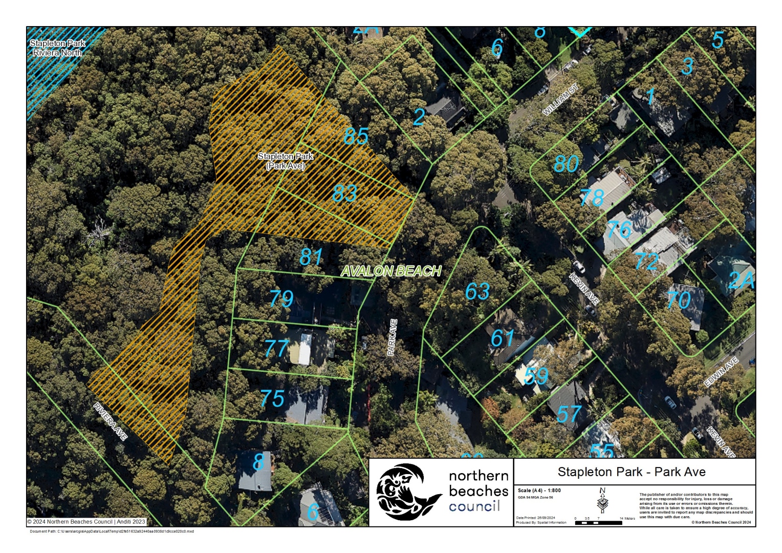
| Stapleton Park (Park Ave) | Stapleton Park, 11A Riviera Avenue, Avalon Beach | View | 0.4 | Extreme | Fire & Rescue NSW | Ready |
| OTHER AGENCY PROPOSALS | ||||||
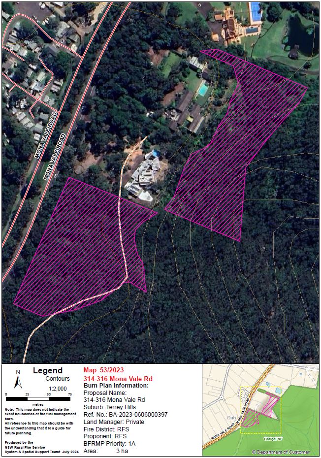
| 313 Mona Vale Rd | Adjacent to 316 Mona Vale Road, Terrey Hills | View | 1.6 | Extreme | NSW Rural Fire Service | Other Agency Proposal |
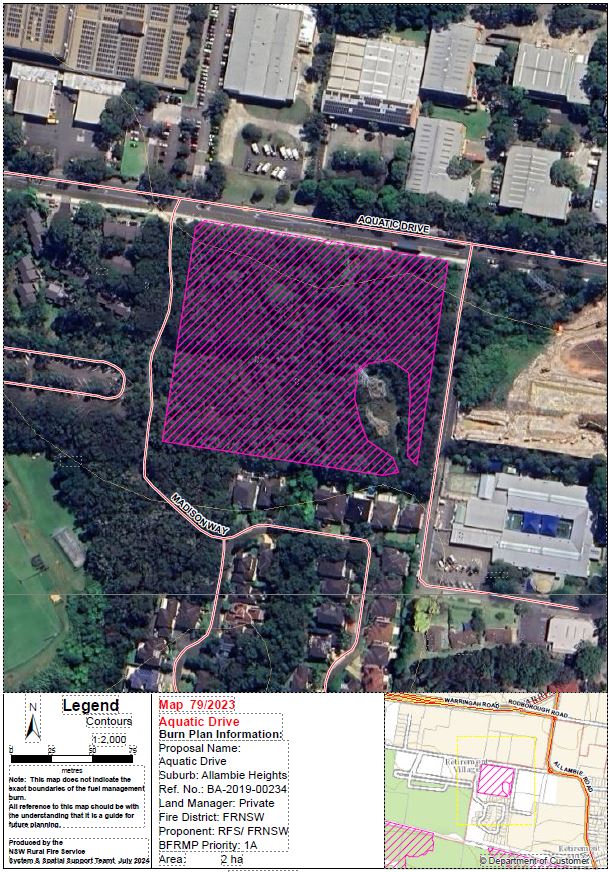
| Aquatic Drive (Council) | Madison Way Reserve, Madison Way, Allambie Heights | View | 0.2 | Extreme | Fire & Rescue NSW | Other Agency Proposal |
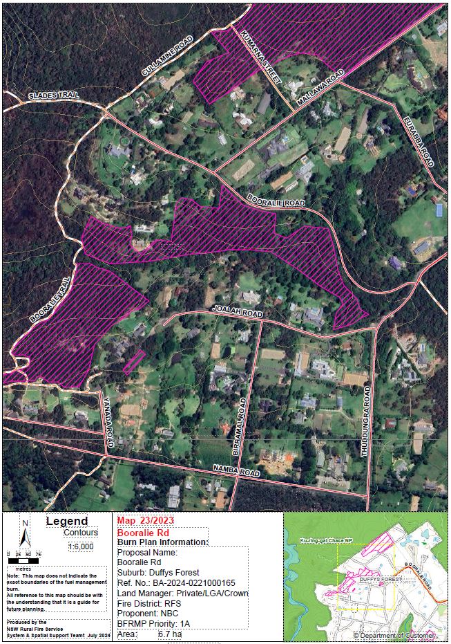
| Booralie Road | Between Booralie Road and Joalah Road, Duffys Forest | View | 7.5 | Extreme | NSW Rural Fire Service | Other Agency Proposal |
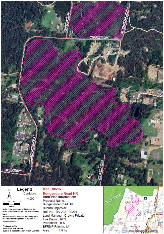
| Bungendore Street HR | Adjacent to Bungendore Street and McCowen Road, Ingleside | View | 15 | Extreme | NSW Rural Fire Service | Other Agency Proposal |
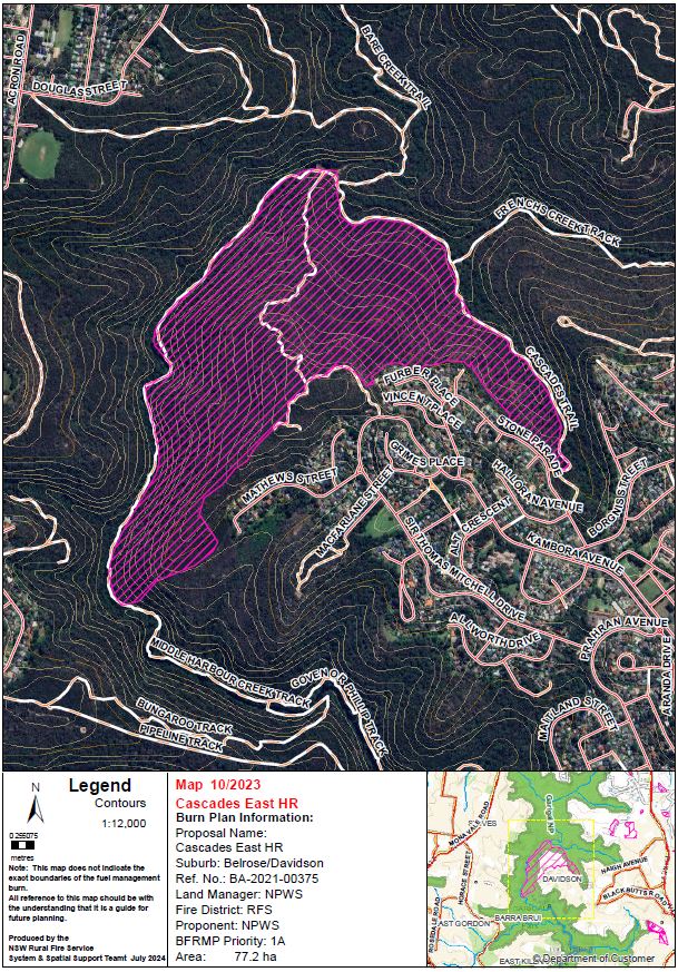
| Cascades East HR | Cascades Trail, Belrose / Davidson | View | 77 | Extreme | NSW National Parks & Wildlife Services | Other Agency Proposal |
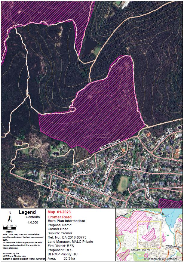
| Cromer Road | Between Cromer Road and Cromer Wakehurst Trail, Cromer | View | 20 | Extreme | NSW Rural Fire Service | Other Agency Proposal |
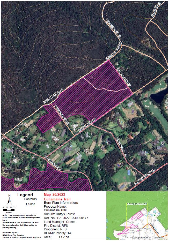
| Cullamine Trail | Between Cullamine Road and Mallawa Road, Duffys Forest | View | 13 | Extreme | NSW Rural Fire Service | Other Agency Proposal |
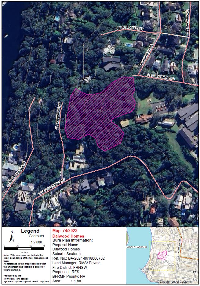
| Dalwood Homes | Adjacent to Gurney Crescent and Clavering Road, Seaforth | View | 1.1 | Extreme | NSW Rural Fire Service | Other Agency Proposal |
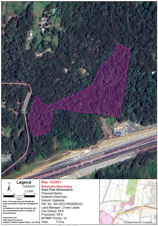
| Katandra Sanctuary | Adjacent to Mona Vale Road and Lane Cove Road, Ingleside | View | 1.8 | Extreme | NSW Rural Fire Service | Other Agency Proposal |
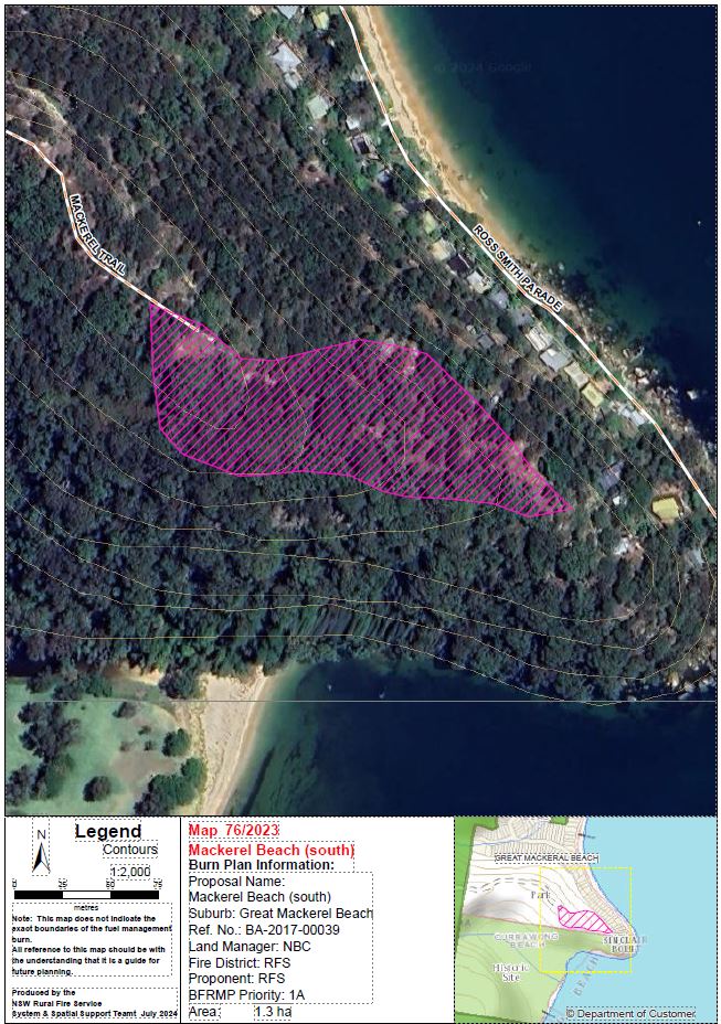
| Mackerel Beach (south) | Great Mackerel Beach Reserve, Monash Avenue, Great Mackerel Beach | View | 5.3 | Extreme | NSW Rural Fire Service | Other Agency Proposal |
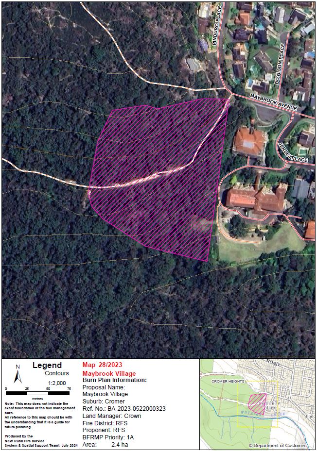
| Maybrook Village | Maybrook Avenue, Cromer | View | 2.4 | Extreme | NSW Rural Fire Service | Other Agency Proposal |
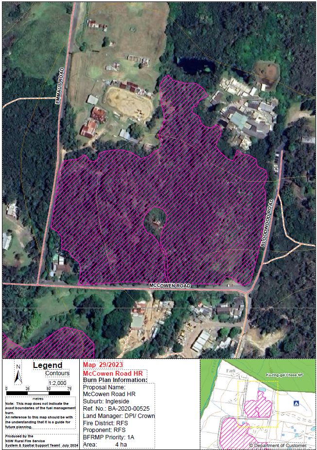
| McCowen Road HR | McCowen Road, Ingleside | View | 3.7 | Extreme | NSW Rural Fire Service | Other Agency Proposal |
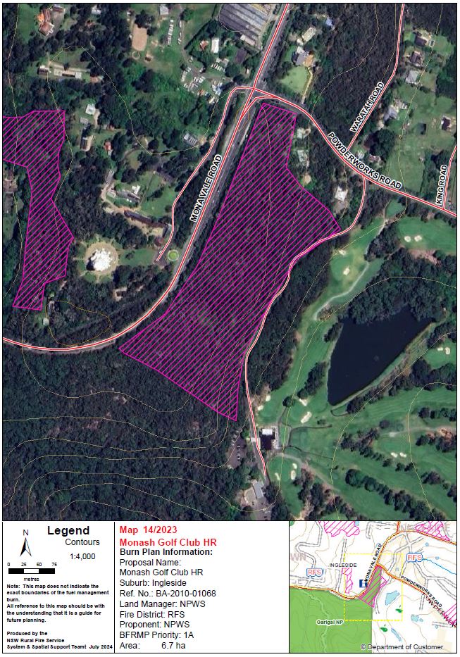
| Monash Golf Club HR | Between Mona Vale Road and Monash Golf Club, Ingleside | View | 6.7 | Extreme | NSW Rural Fire Service | Other Agency Proposal |
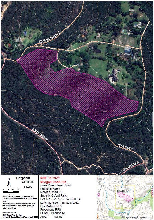
| Morgan Road HR | Between Morgan Road, Kellys Way, and Slippery Dip Trail, Belrose / Oxford Falls | View | 8.7 | Extreme | NSW Rural Fire Service | Other Agency Proposal |
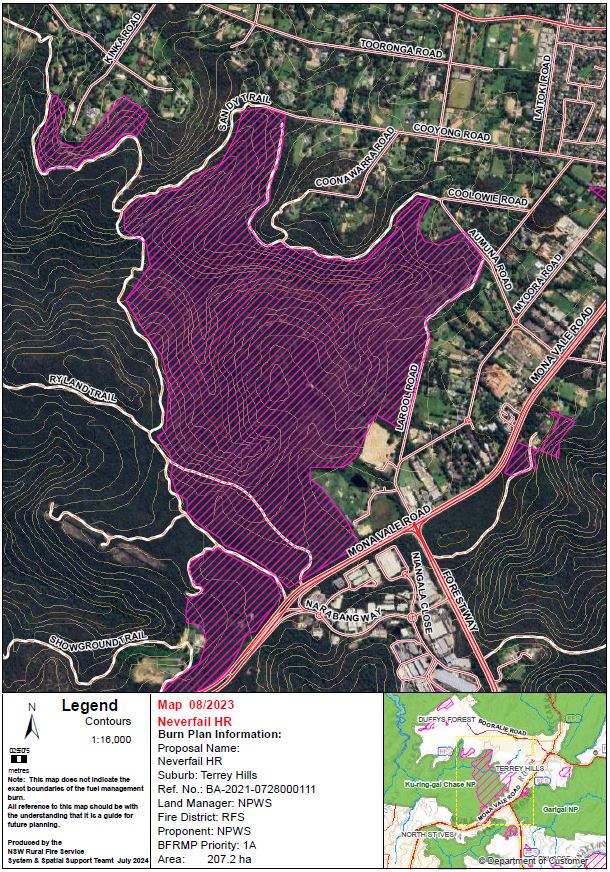
| Neverfail HR | Between Mona Vale Road, Larool Road, and Sandy Trail, Terrey Hills | View | 207 | Extreme | NSW National Parks & Wildlife Services | Other Agency Proposal |
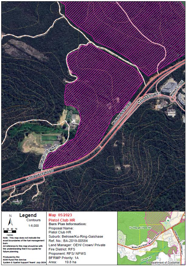
| Pistol Club HR | Between Mona Vale Road, Ryland Trail, Belrose | View | 20 | Extreme | NSW Rural Fire Service | Other Agency Proposal |
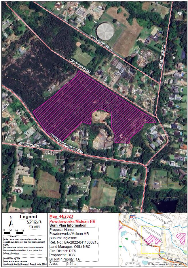
| Powderworks Rd/ McLean Street | Between Powderworks Road and McLean Street, Ingleside | View | 6.5 | Extreme | NSW Rural Fire Service | Other Agency Proposal |
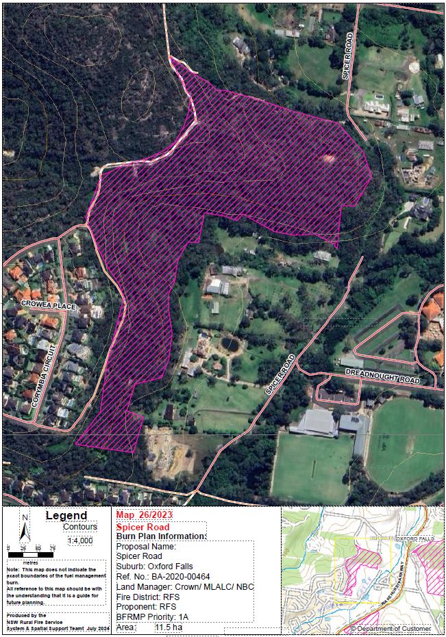
| Spicer Rd | Spicer Road, Oxford Falls | View | 10.7 | Extreme | NSW Rural Fire Service | Other Agency Proposal |
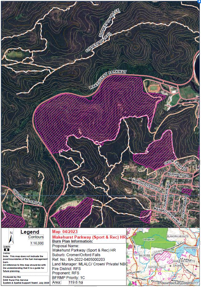
| Sport and Rec / Wakehurst PW HR | Wakehurst Parkway, Oxford Falls / Cromer | View | 120 | Extreme | NSW Rural Fire Service | Other Agency Proposal |
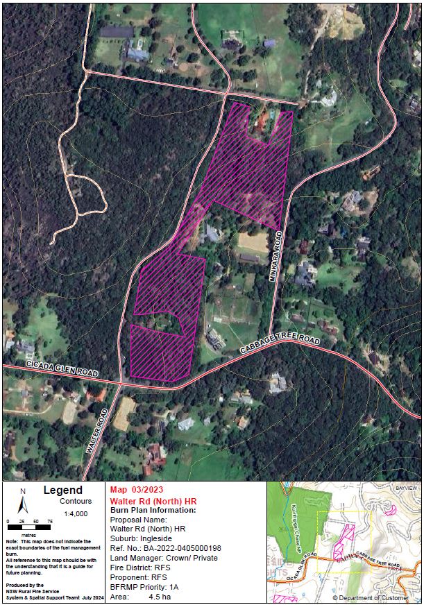
| Walter Rd (North) HR | Between Walter Road, Cabbage Tree Road, Minkara Road, Ingleside | View | 4.5 | Extreme | NSW Rural Fire Service | Other Agency Proposal |
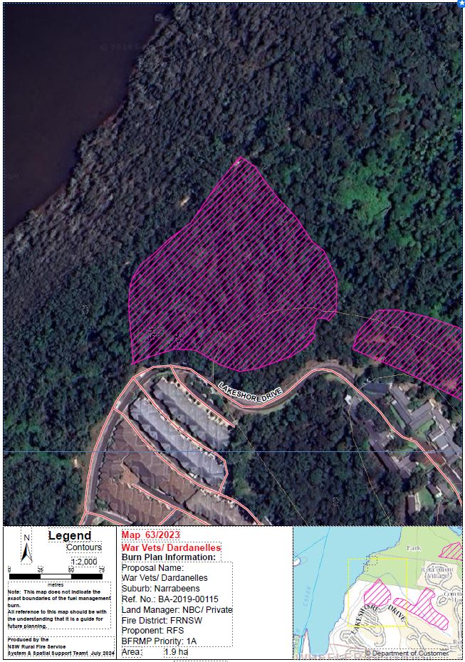
| War Vets Dardanelles | Lakeshore Drive, Narrabeen | View | 1.9 | Extreme | Fire & Rescue NSW | Other Agency Proposal |
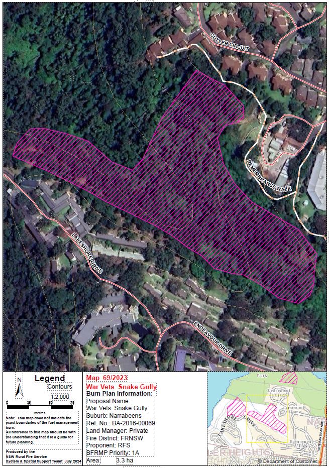
| War Vets Snake Gully | Lakeshore Drive, Narrabeen | View | 3.3 | Extreme | Fire & Rescue NSW | Other Agency Proposal |
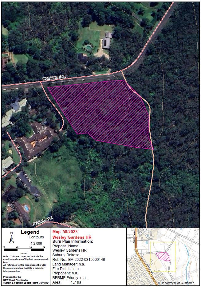
| Wesley Gardens HR | Adjacent to Morgan Road and Forest Way, Belrose | View | 1.7 | Extreme | NSW Rural Fire Service | Other Agency Proposal |
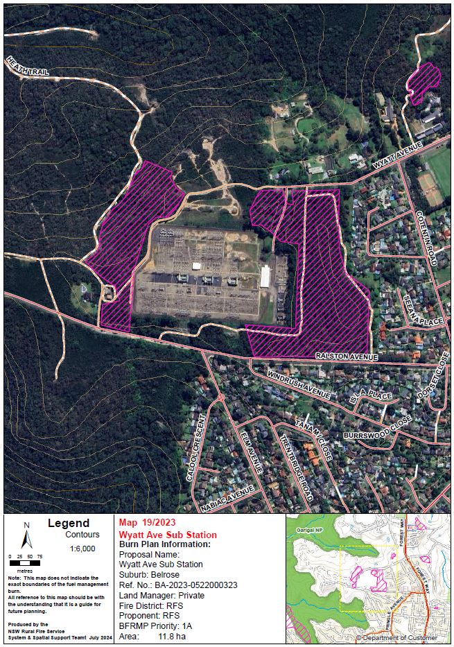
| Wyatt Ave Sub Station | Between Ralston Ave and Wyatt Ave, Belrose | View | 11.8 | Extreme | NSW Rural Fire Service | Other Agency Proposal |
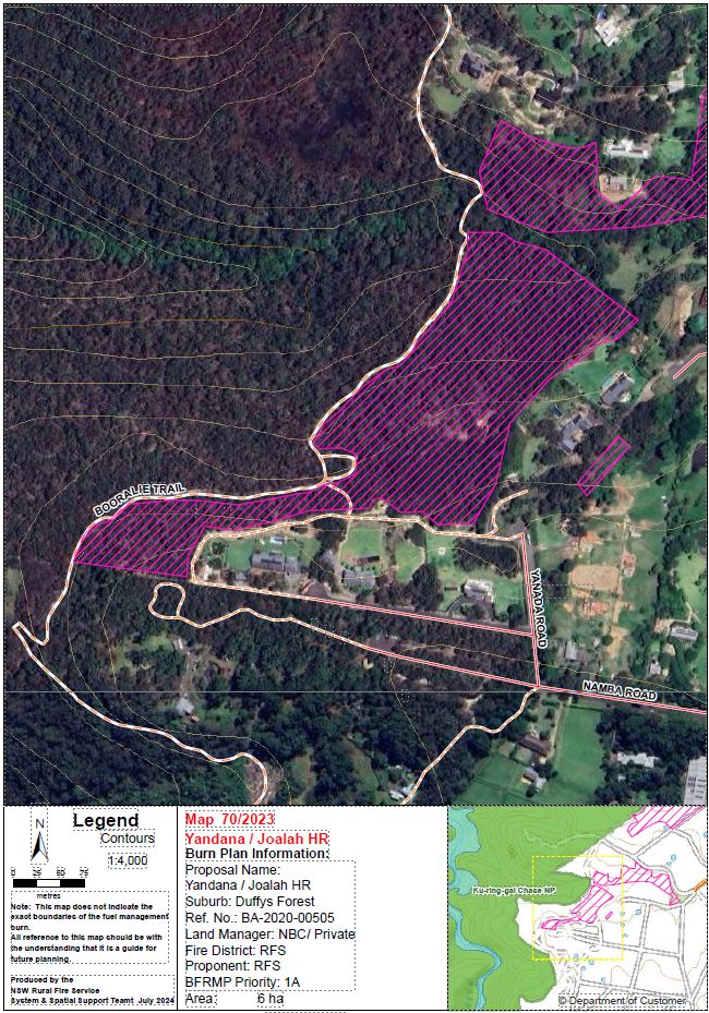
| Yanada / Joalah Rd | Between Yanada Road and Joalah Road, Duffys Forest | View | 8 | Extreme | NSW Rural Fire Service | Other Agency Proposal |
Completed burns 2024 / 2025
| BURN | LOCATION | MAP | SIZE (HA) | BUSH FIRE RISK RATING | LEAD AGENCY | COMPLETED |
|---|---|---|---|---|---|---|
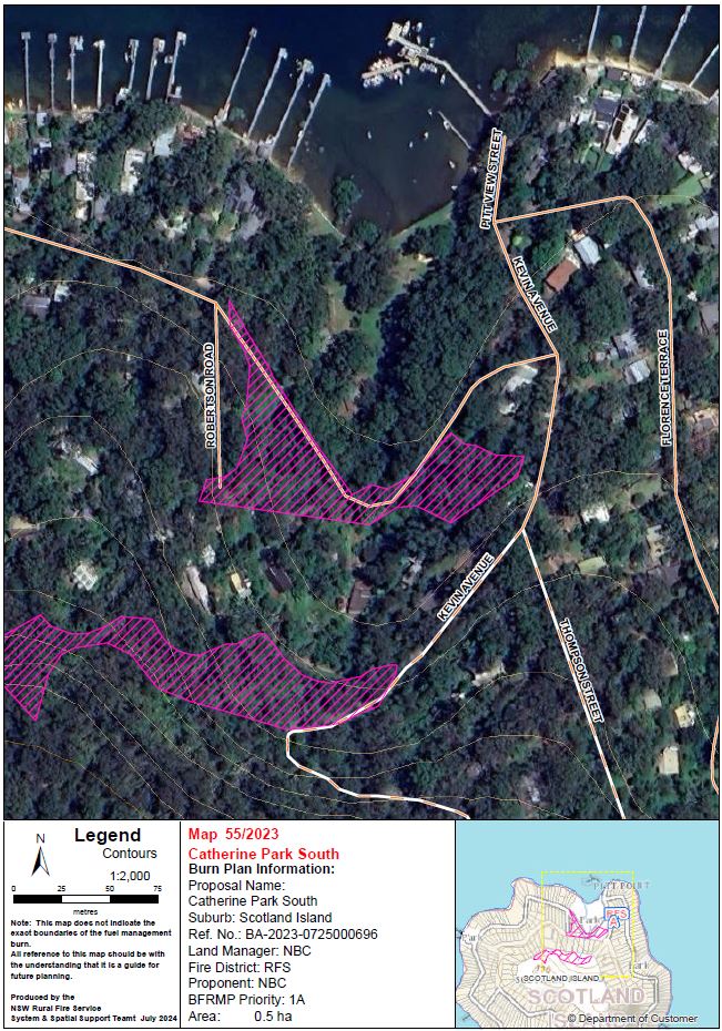
| Catherine Park South | Catherine Park, Robertson Road, Scotland Island | View | 0.5 | Extreme | Fire & Rescue NSW | 4/1/2025 |
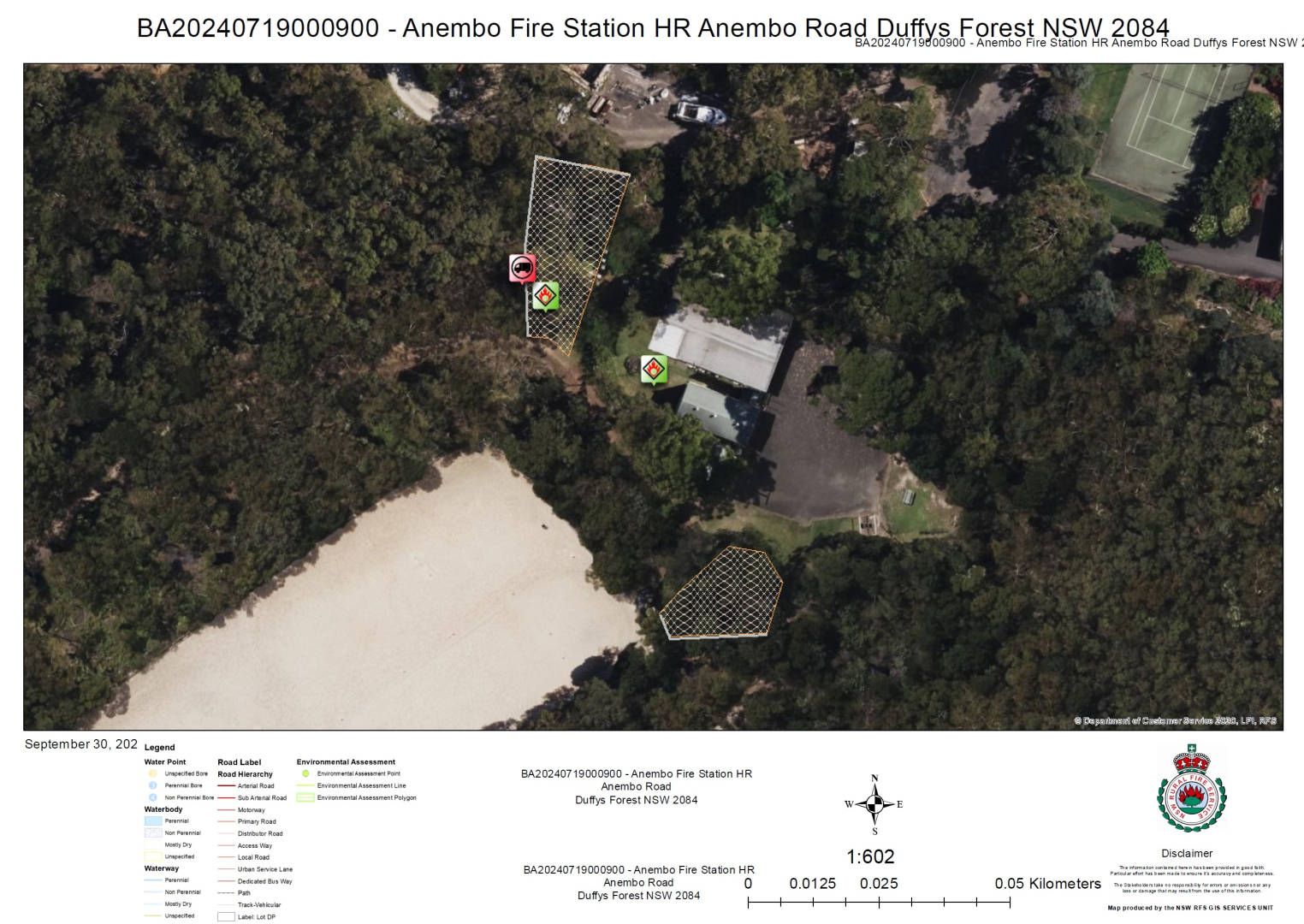
| Anembo Fire Station HR | Anembo Reserve, Anembo Road, Duffys Forest | View | 0.05 | Extreme | NSW Rural Fire Service | 24/11/2024 |
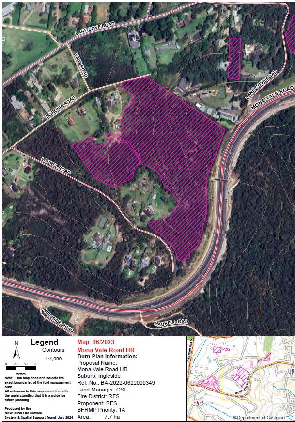
| Mona Vale Road HR | Between Mona Vale Road and Boronia Road, Ingleside | View | 7.7 | Extreme | NSW Rural Fire Service | 14/11/2024 & 8/9/2024 |
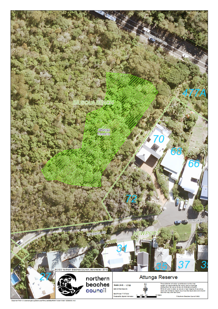
| Attunga Reserve | Attunga Reserve, 477 Barrenjoey Road, Bilgola Beach | View | 0.3 | Extreme | Fire & Rescue NSW | 28/10/2024 |
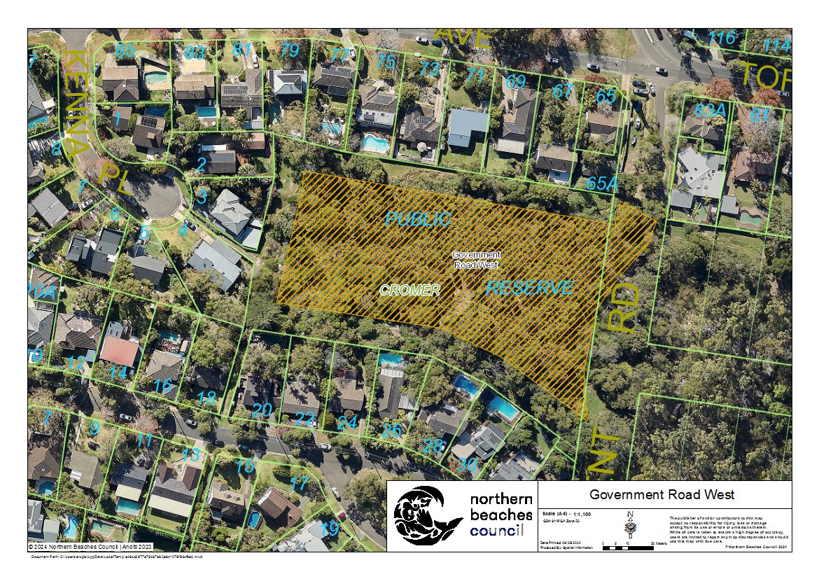
| Government Road West | Government Road Reserve, Government Road, Cromer | View | 0.8 | Extreme | Fire & Rescue NSW | 23/10/2024 |
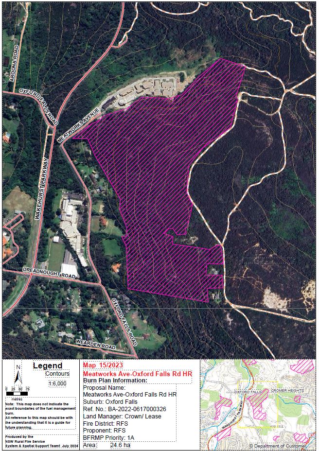
| Meatworks Ave -Oxford Falls Rd HR | Rear of Meatworks Avenue, Oxford Falls | View | 24 | Extreme | NSW Rural Fire Service | 21/9/2024 |
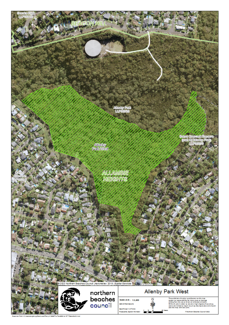
| Allenby Park West | Allenby Park, rear of Owen Stanley Avenue, Allambie Heights | View | 10 | Extreme | Fire & Rescue NSW | 10/9/2024 |
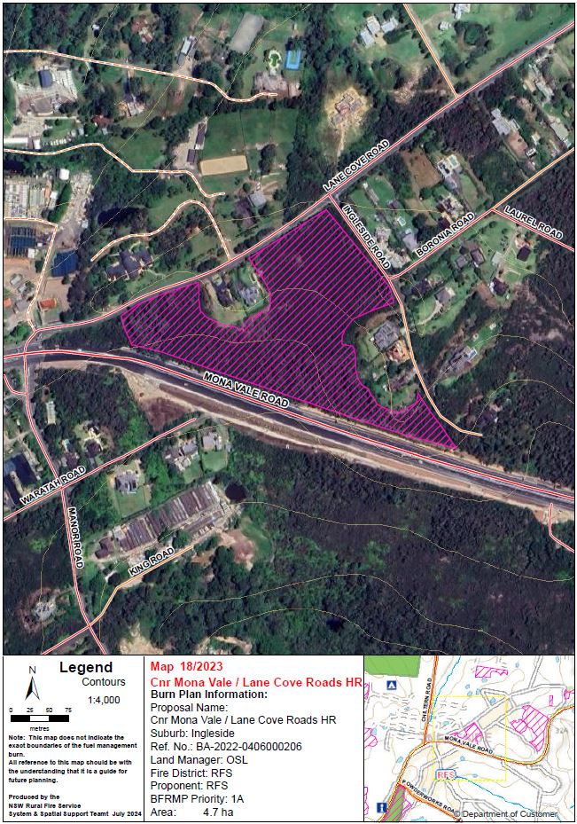
| Cnr Mona Vale / Lane Cove Roads HR | Between Mona Vale Road, Ingleside Road, and Lane Cove Road, Ingleside | View | 4.6 | Extreme | NSW Rural Fire Service | 8/9/2024 |
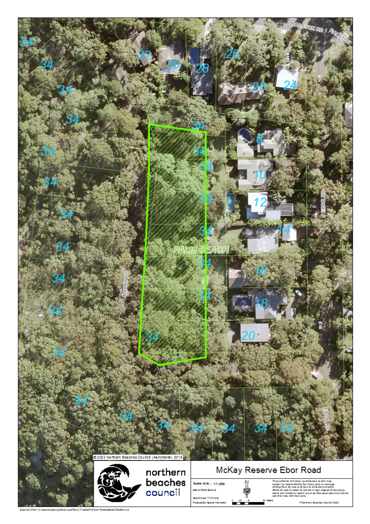
| McKay Reserve, Ebor Road | Mckay Reserve, McKay Road, Palm Beach | View | 0.5 | Extreme | Fire & Rescue NSW | 5/9/2024 |
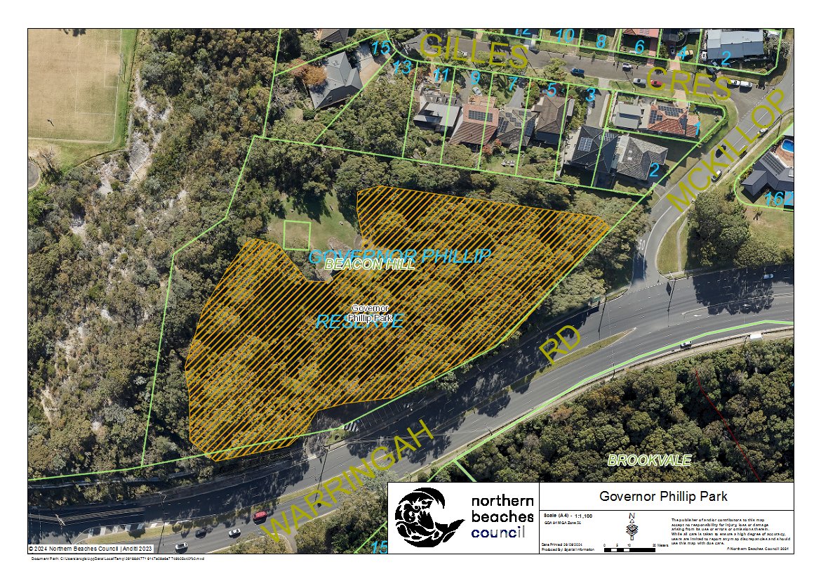
| Governor Phillip Park | Governor Phillip Lookout Reserve, Warringah Road, Beacon Hill | View | 1.4 | Extreme | NSW Rural Fire Service | 31/8/2024 |
Completed burns 2023 / 2024
| BURN | LOCATION | MAP | SIZE (HA) | BUSH FIRE RISK RATING | LEAD AGENCY | COMPLETED |
|---|---|---|---|---|---|---|
| Pistol Club HR | Mona Vale Road, Belrose | View | 11 | Extreme | NSW Rural Fire Service | 18/3/2024 |
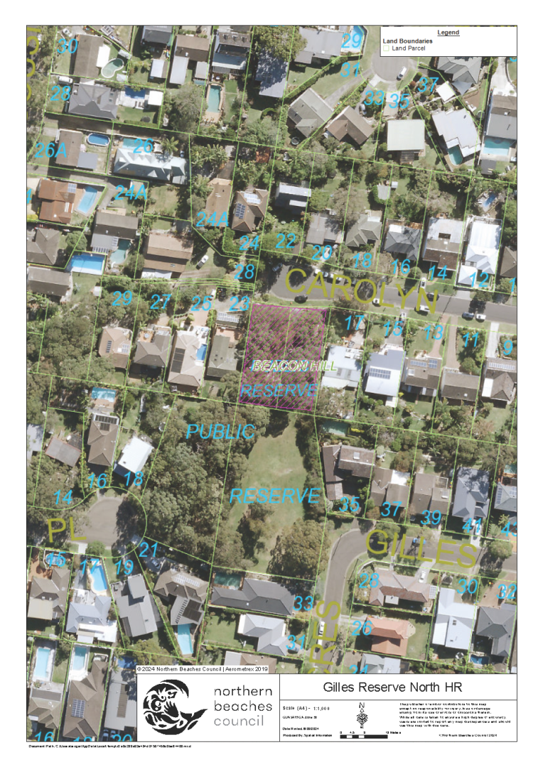
| Gillies Reserve North | Gillies Reserve, Gillies Crescent, Beacon Hill | View | 0.1 | N/A | Fire & Rescue NSW | 12/03/2024 |
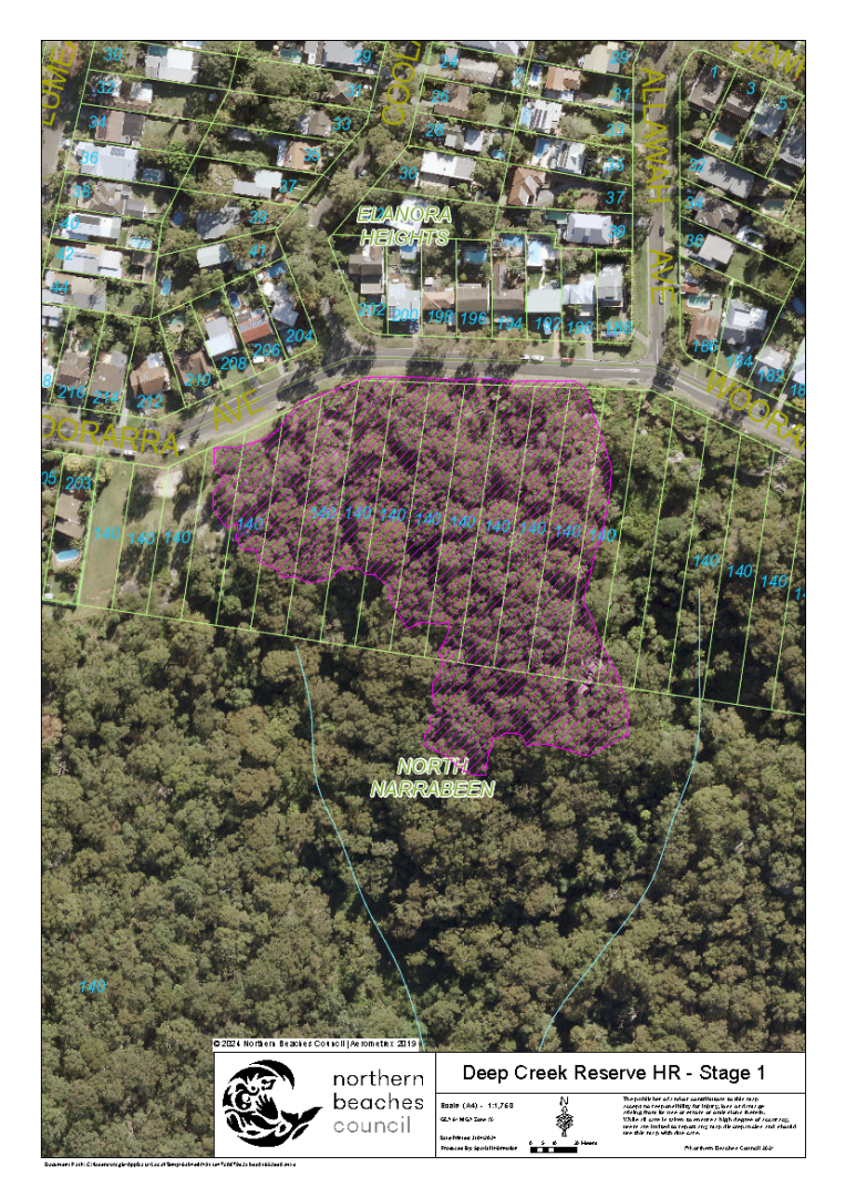
| Deep Creek Reserve - Stage 1 | Deep Creek Reserve, Woorarra Avenue, North Narrabeen | View | 1.9 | Extreme | NSW Rural Fire Service | 09/03/2024 |
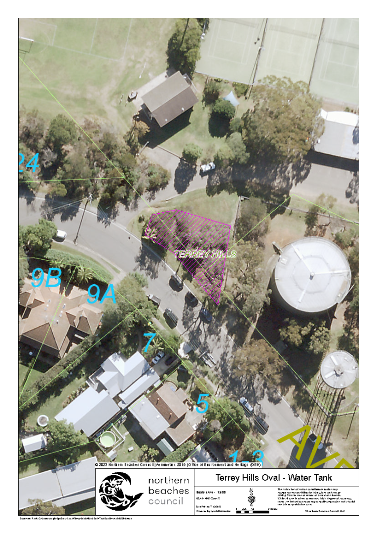
| Terrey Hills Oval - Water Tank | Terrey Hills Oval, Beltana Avenue, Terrey Hills | View | 0.1 | Extreme | NSW Rural Fire Service | 18/12/2023 |
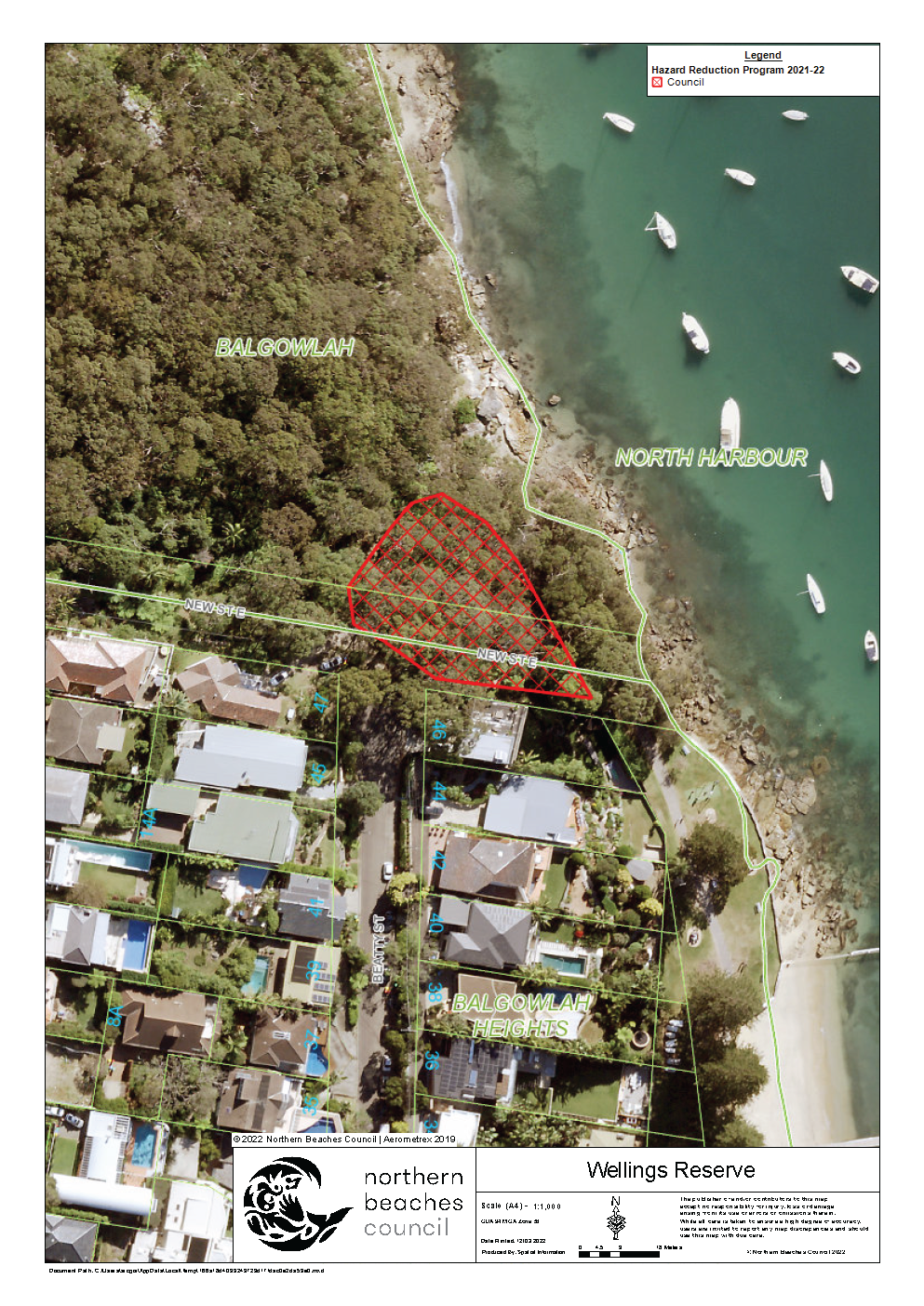
| Wellings Reserve | Wellings Reserve, Gourlay Avenue, Balgowlah | View | 0.1 | High | Fire & Rescue NSW | 02/11/2023 |
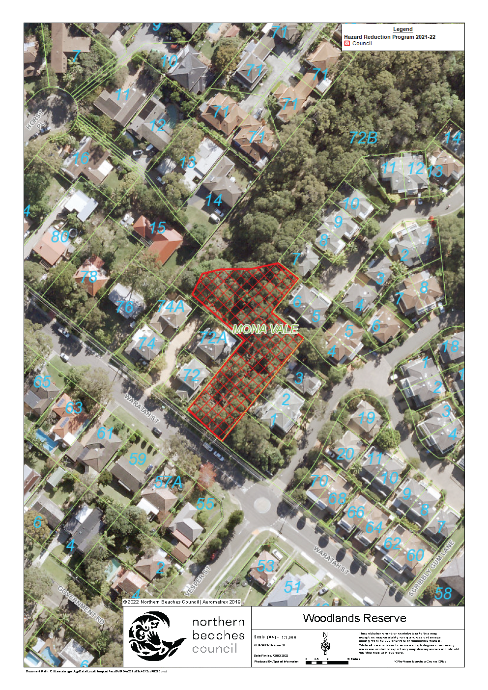
| Woodlands Reserve | Woodlands Reserve, Waratah Street, Mona Vale | View | 0.1 | High | Fire & Rescue NSW | 02/11/2023 |
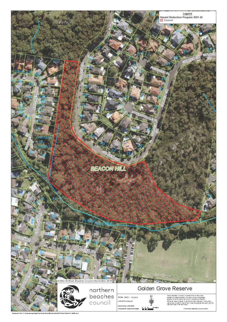
| Golden Grove Reserve | Golden Grove, 53 Golden Grove, Beacon Hill | View | 2.6 | Extreme | Fire & Rescue NSW | 23/10/2023 & 14/10/2023 |
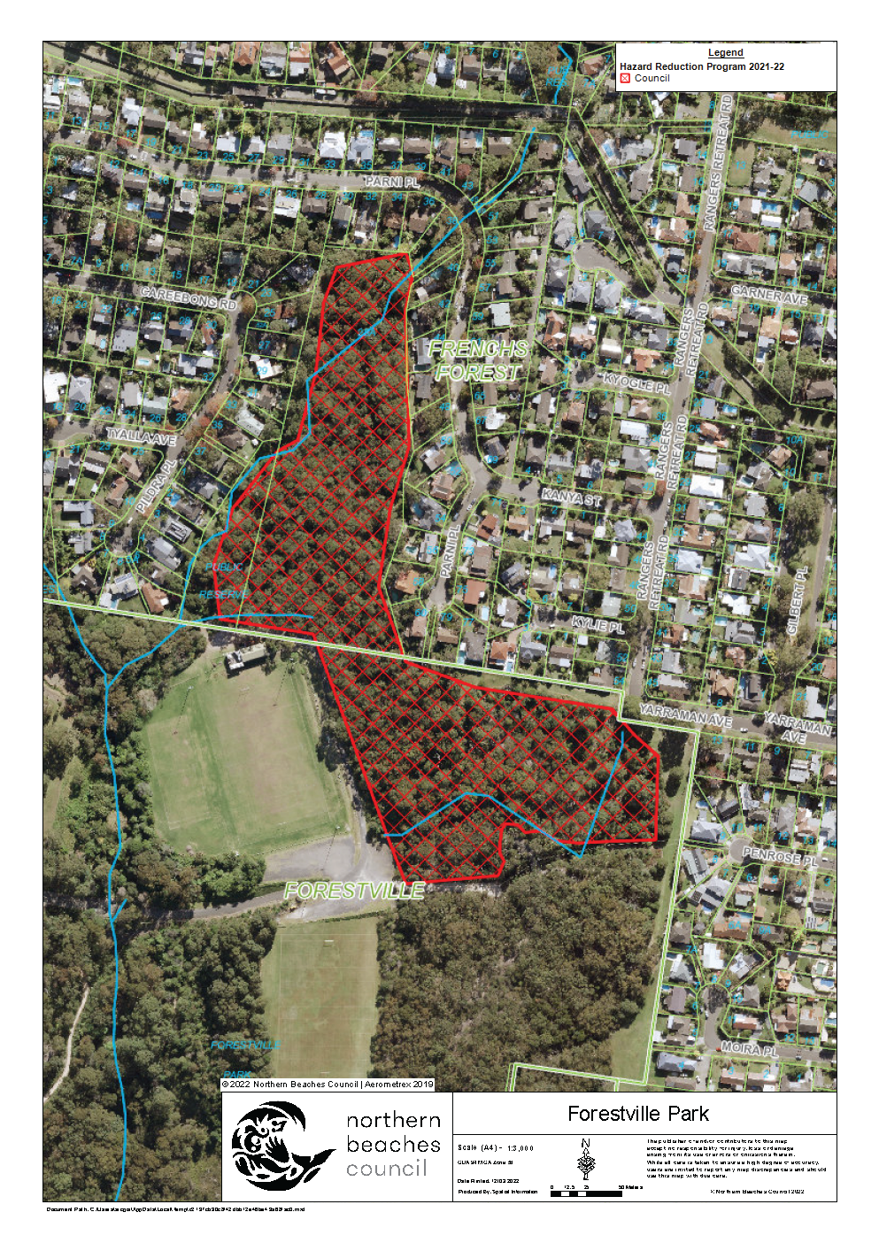
| Forestville Park | Forestville Park, Currie Road, Forestville | View | 4.6 | Extreme | NSW Rural Fire Service | 15/10/2023 |
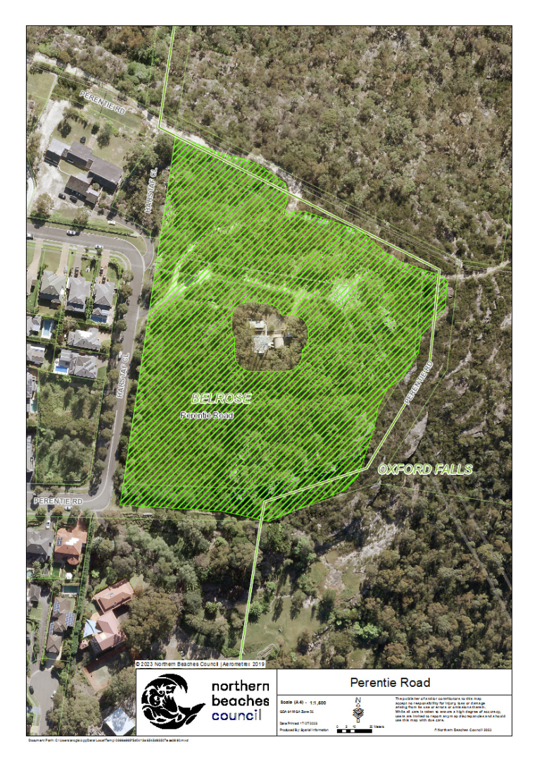
| Perentie Road | Perentie Park, Perentie Road, Belrose | View | 2.6 | Extreme | NSW Rural Fire Service | 14/10/2023 |
| Elizabeth Park North | Elizabeth Park, Thompson Street, Scotland Island | View | 0.3 | Extreme | NSW Rural Fire Service | 30/09/2023 |
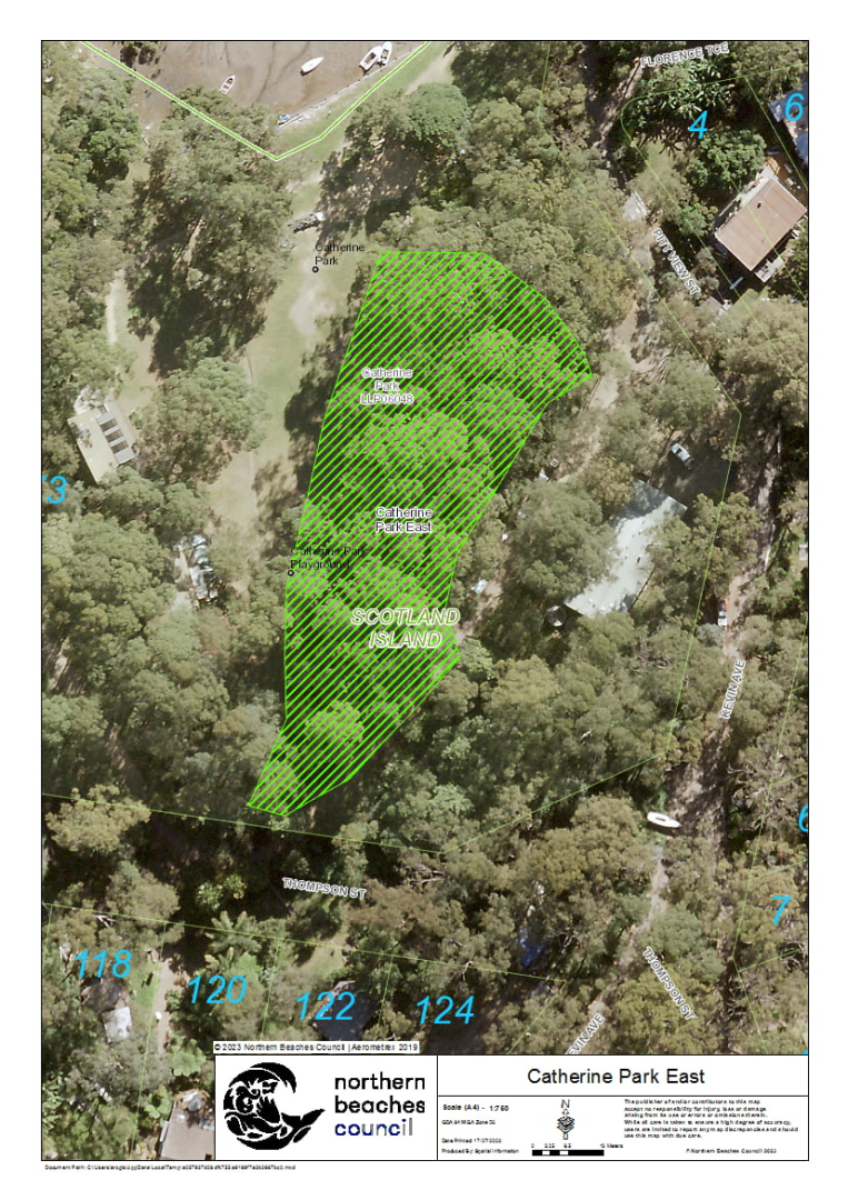
| Catherine Park East | Catherine Park, Robertson Road, Scotland Island | View | 0.3 | Extreme | NSW Rural Fire Service | 23/09/2023 |
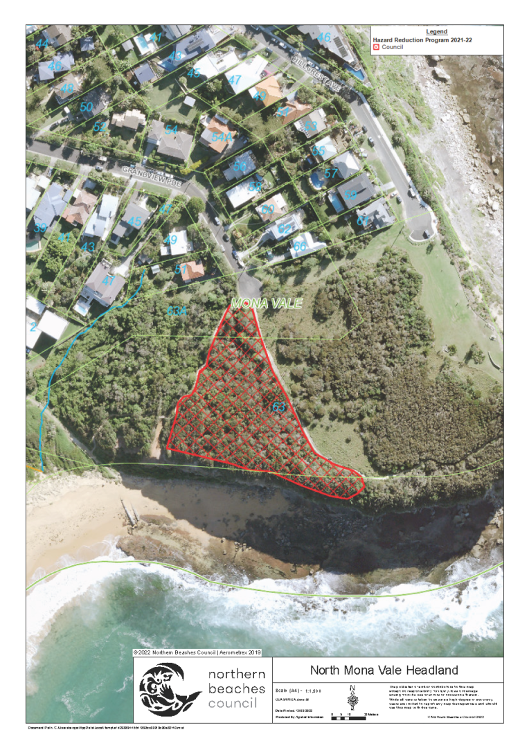
| North Mona Vale Headland | North Mona Vale Headland Reserve, Hillcrest Avenue, Mona Vale | View | 0.5 | N/A | Fire & Rescue NSW | 06/09/2023 |
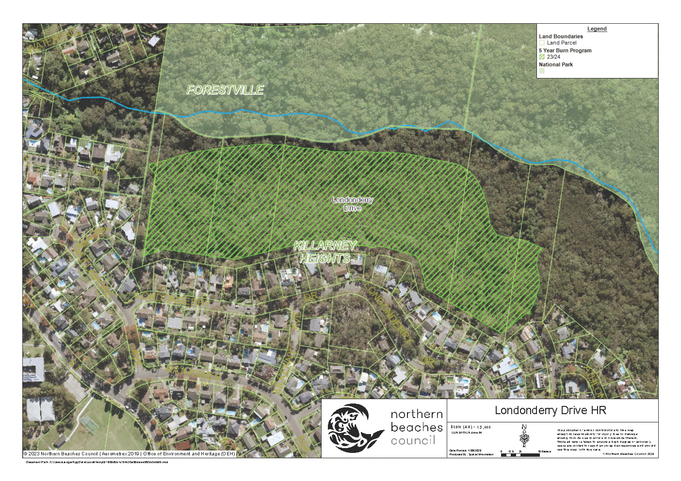
| Londonderry Drive | Londonderry Drive Reserve, Londonderry Drive, Killarney Heights | View | 7 | Extreme | NSW Rural Fire Service | 05/08/2023 |
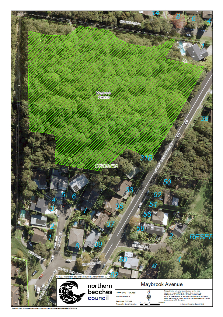
| Maybrook Avenue | Maybrook Avenue, Cromer | View | 2.2 | Extreme | NSW Rural Fire Service | 05/08/2023 |
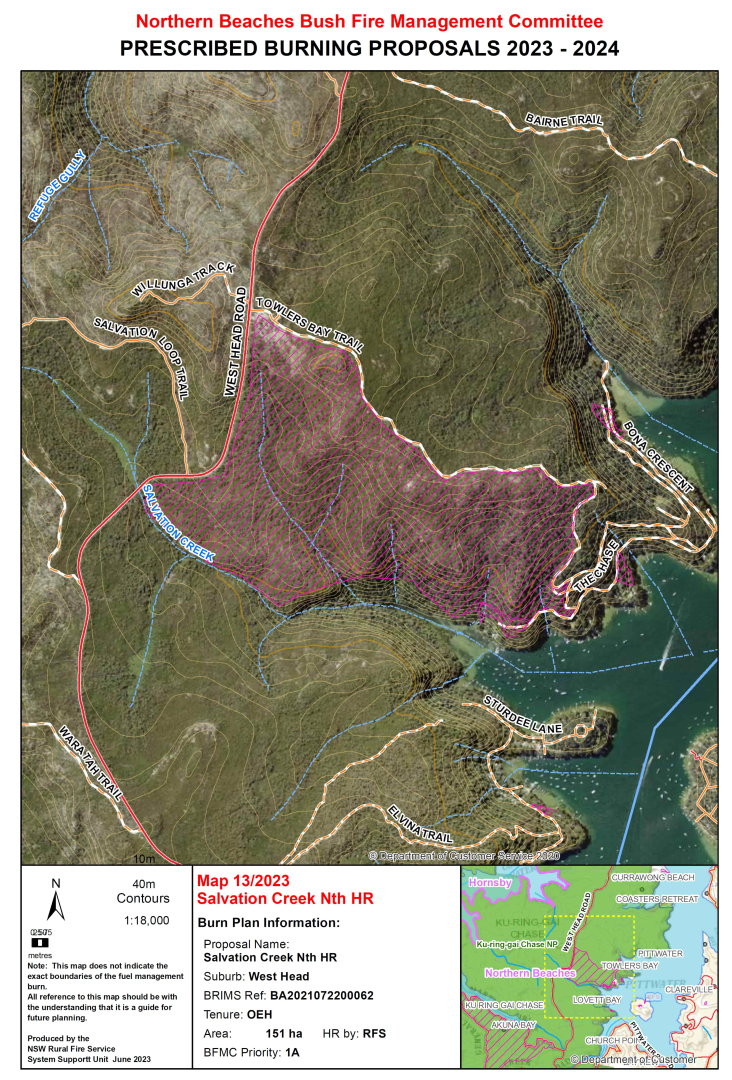
| Salvation Creek Nth HR | Ku-ring-gai Chase National Park, Lovett Bay | View | 165.5 | Extreme | NSW National Parks & Wildlife Service | 04/08/2023 |
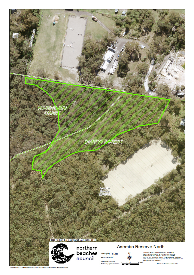
| Anembo Reserve | Anembo Reserve, Anembo Road, Duffys Forest | View | 0.9 | Extreme | NSW Rural Fire Service | 15/07/2023 |
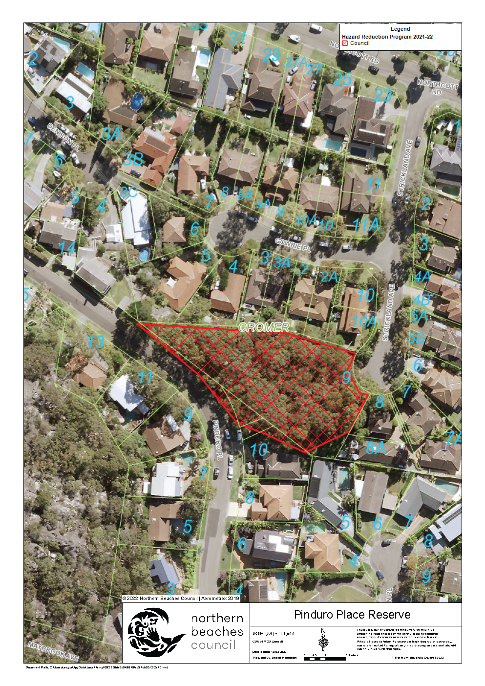
| Pinduro Place Reserve | Pinduro Place Reserve, Pinduro Place, Cromer | View | 0.3 | Extreme | Fire & Rescue NSW | 14/07/2023 |
Completed burns 2022 / 2023
| BURN | LOCATION | MAP | SIZE (HA) | BUSH FIRE RISK RATING | LEAD AGENCY | COMPLETED |
|---|---|---|---|---|---|---|
| Angophora SFAZ 678 | Angophora SFAZ 678 | View | 1.7 | Extreme | Fire & Rescue NSW | 21/06/2023 |
| Anembo Reserve | Anembo Reserve, Anembo Road, Duffys Forest | View | 0.92 | Extreme | NSW Rural Fire Service | 03/06/2023 |
| Chesterman Crescent | Chesterman Crescent, Davidson | View | 0.24 | Extreme | Fire & Rescue NSW | 06/05/2023 |
| Algona Reserve | Algona Reserve, 9 Algona Street, Bilgola Plateau | View | 0.5 | Extreme | Fire & Rescue NSW | 05/05/2023 |
| North Bilgola Headland | South Avalon / North Bilgola Headland, The Serpentine, Bilgola Beach | View | 0.4 | Extreme | Fire & Rescue NSW | 03/05/2023 |
| Kens Reserve North | Kens Road Reserve, Kens Road, Frenchs Forest | View | 0.4 | Medium | Fire & Rescue NSW | 10/03/2023 |
| Jamieson Park - Veterans Parade | Jamieson Park, The Esplanade, Narrabeen | View | 0.7 | Extreme | Fire & Rescue NSW | 09/03/2023 |
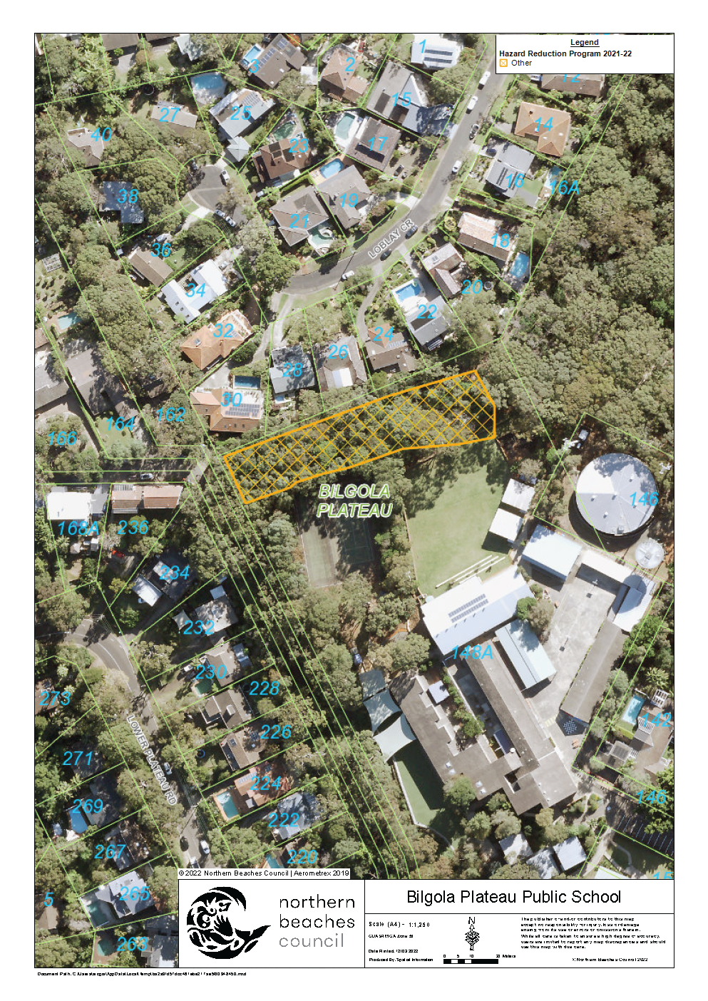
| Bilgola Plateau Public School | 148A Plateau Road, Bilgola Plateau | View | 0.3 | Medium | Fire & Rescue NSW | 12/01/2023 |
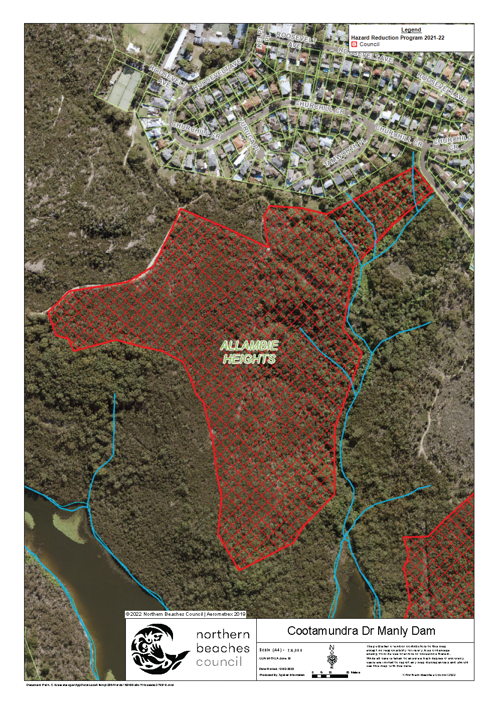
| Cootamundra Drive Manly Dam | Manly Warringah War Memorial Park, rear of Churchill Crescent, Allambie Heights | View | 16.9 | Extreme | NSW Rural Fire Service | 03/12/2022 |
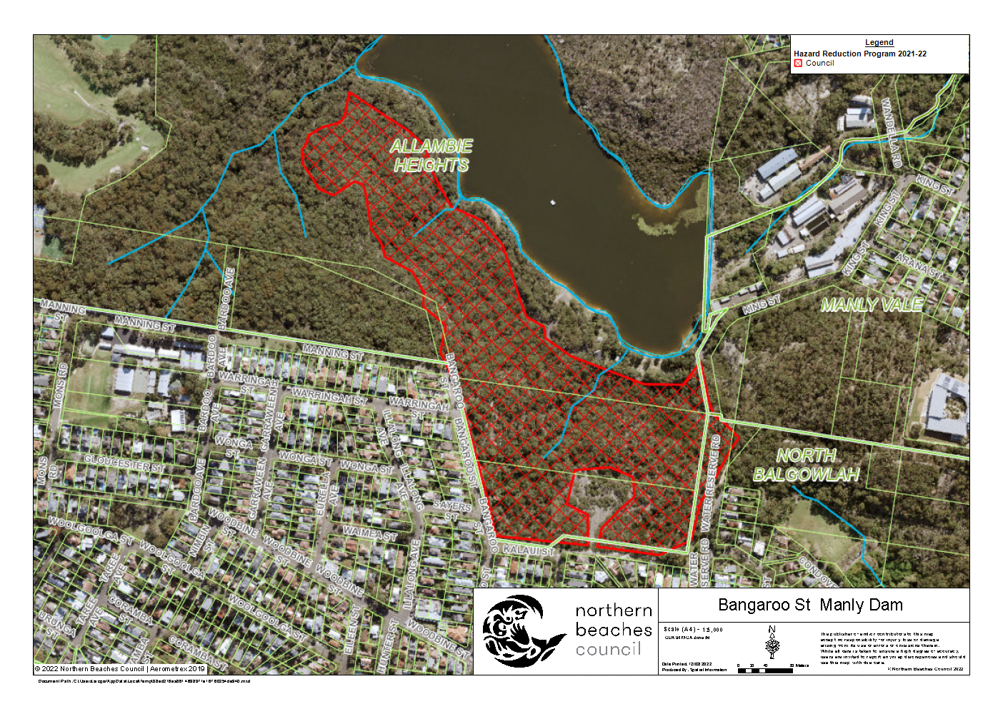
| Bangaroo St Manly Dam | Manly Warringah War Memorial Park, rear of Bangaroo Street, Allambie Heights | View | 13.5 | Extreme | NSW Rural Fire Service | 12/11/2022 |
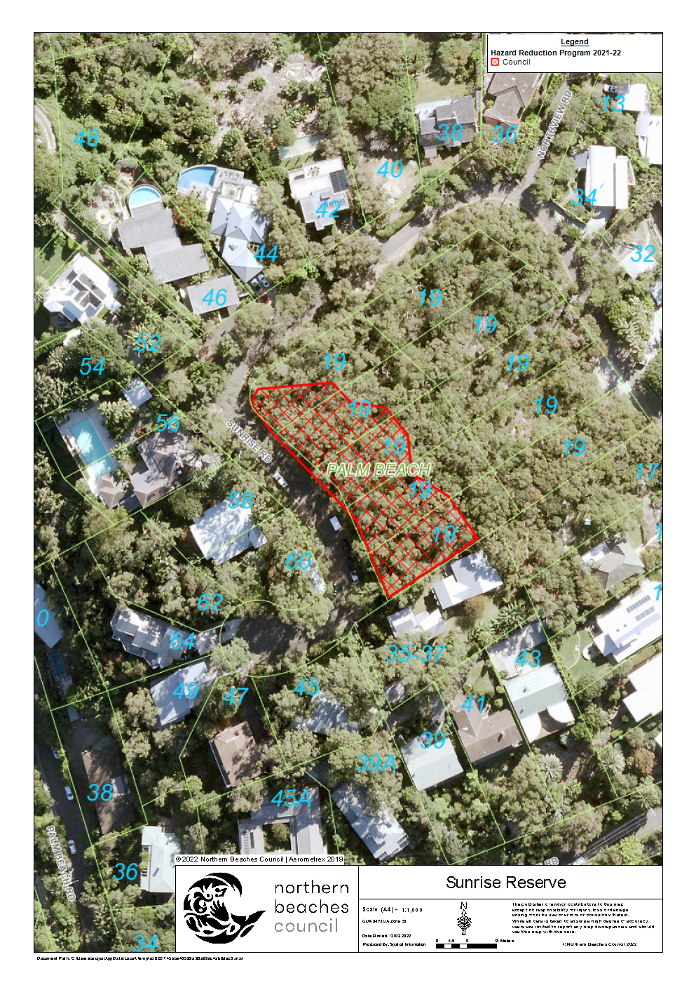
| Sunrise Reserve | Sunrise Reserve, Sunrise Road, Palm Beach | View | 0.2 | Medium | Fire & Rescue NSW | 24/11/2022 |
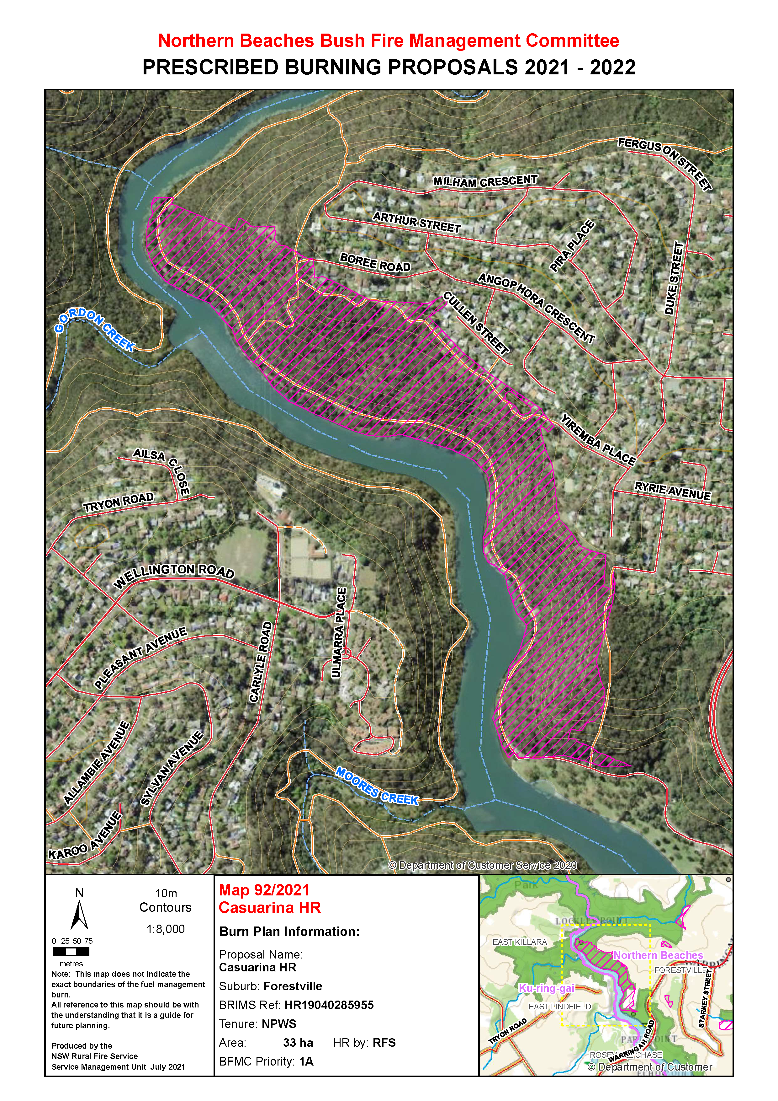
| Casuarina | Between Boree Road and Bridgeview Crescent, Forestville | View | 33 | Extreme | NSW National Parks & Wildlife Service | 11/11/2022 |
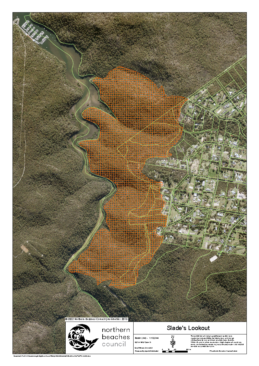
| Slade's Lookout | Booralie Road to Bibbenluke Avenue, Duffy’s Forest | View | 175 | Extreme | NSW National Parks & Wildlife Service | 05/11/2022 |
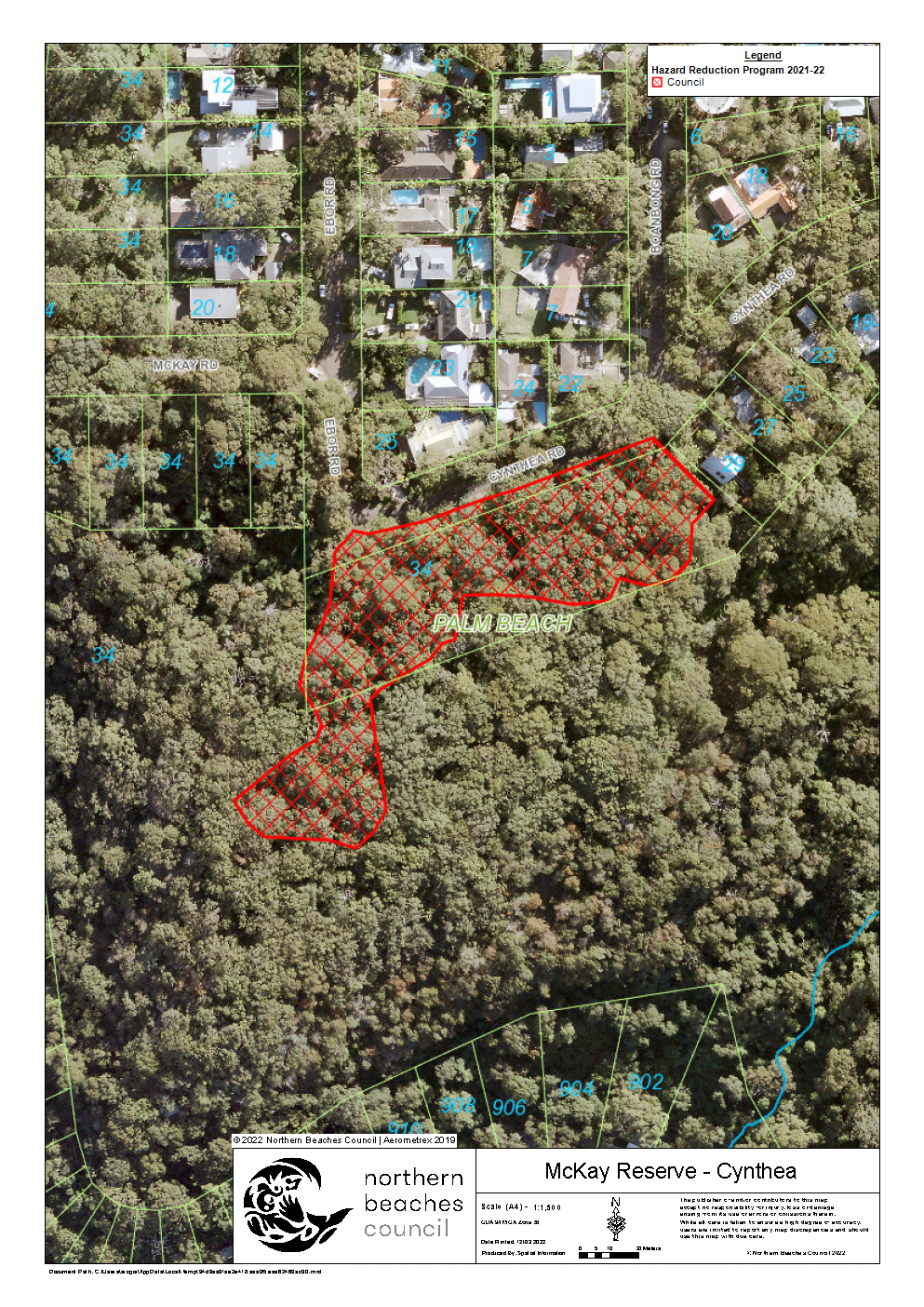
| McKay Reserve - Cynthea | Mckay Reserve, McKay Road, Palm Beach | View | 0.6 | Extreme | Fire & Rescue NSW | 03/11/2022 |
Completed burns 2021 / 2022
- Bushrangers Hill - Bungan Head Road, Newport - 17/02/22
- Ronald Reserve - Ronald Avenue, Freshwater - 28/01/22
- Lady Davidson Carroll Creek - Lady Davidson Circuit, Forestville - 27/10/21
- Cicada Glen HR (Bayview Heights) - Mccarrs Creek Road, Church Point (NPWS/Council) - 9/10/21
- Currawong Lodge - Currawong Beach - 10/09/21
- Gwarra Reserve - Davidson Avenue, Forestville - 03/09/21
- Madison Way Pipeline - Madison Way, Allambie Heights - 03/09/21
- Kinka Reserve - Kinka Road, Terrey Hills - 23/08/21
- Pathilda Reserve - Florence Terrace, Scotland Island - 22/08/21
- Elizabeth Park - Thompson Street, Scotland Island - 22/08/21
- Nyrang Road Manly Dam - Roosevelt Avenue, Allambie Heights - 22/08/21
- Chesterman Av SFAZ - Sir Thomas Mitchell Drive, Davidson (NPWS/Crown/Council) - 20/08/21
- Bungoona Elanora Heights - Bungoona Ave, Elanora Heights (Private/Council) - 20/08/21
- Sydney Conference Centre SFAZ 5 - Ingleside Road, Ingleside - 20/08/21
- Stony Range APZ - Pittwater Road, Dee Why - 19/08/21
- McKay SFAZ 10 - McKay Road, Palm Beach - 17/08/21
- Slippery Dip HR - Wakehurst Parkway, Narrabeen (NPWS/Crown/Council/Private) - 13/08/21
Completed burns 2020 / 2021
- Corymbia Circuit Wearden - Corymbia Circuit Reserve, Corymbia Circuit, Frenchs Forest - 01/05/21
- Bates Creek - Londonderry Drive Reserve, Londonderry Drive, Killarney Heights (NPWS/Council) - 26/04/21
- Nandi - Nandi Reserve, Nandi Avenue, Frenchs Forest - 21/11/20
- JJ Hills Kimbriki - J.J. Melbourne Hills Memorial Reserve & Kimbriki Reserve, Kamber Road, Terrey Hills - 20/11/20
- JJ Melbourne Hills LMZ 4 - J.J. Melbourne Hills Memorial Reserve & Kimbriki Reserve, Kamber Road, Terrey Hills - 17/10/20
- Elanora Conference Centre - Ingleside Chase Reserve, Ingleside Road, Ingleside - 15/10/20
- Forestville Park SFAZ 3 - Forestville Park, Currie Road, Forestville - 11/10/20
- Bantry Bay Road Ararat / Scout - Ararat Reserve, Grattan Crescent, Frenchs Forest - 10/10/20
- Kirkwood St Bantry Bay Reserve - Bantry Reserve, Reserve Street, Seaforth - 10/10/20
- Deep Creek Lumeah Ave - Deep Creek Reserve, Woorarra Avenue, North Narrabeen - 4/10/20
- Catherine Park - Catherine Park, Robertson Road, Scotland Island - 27/9/20
- Attunga Reserve - Attunga Reserve, Attunga Road, Newport - 17/9/20
- Churchill Crescent - Manly Warringah War Memorial Park, Roosevelt Avenue, Allambie Heights - 2/9/20
- Southern Cross Way (knoll) - Manly Warringah War Memorial Park, Roosevelt Avenue, Allambie Heights - 30/8/20
- Terrey Hills Oval North and South - Terrey Hills Oval, Beltana Avenue, Terrey Hills - 30/8/20
- Bareena Dr Tania Park Burn Area 2 - Tania Park, Bareena Drive, Balgowlah Heights - 27/8/20
Completed burns 2019 / 2020
- Gumbooya Reserve - Gumbooya Street, Allambie Heights - 27/10/2019
- Elizabeth Park - Thompson Street, Scotland Island - 25/08/2019
- Manly Dam Martin Luther APZ - Roosevelt Avenue, Allambie Heights - 18/08/2019
- Wesley St (Ing Chase) - Ingleside Road, Ingleside - 26/07/2019
Completed burns 2018 / 2019
- Manning Street - Roosevelt Avenue, Allambie Heights - 01/06/2019
- Washington Ave - Washington Avenue, Cromer - 31/05/2019
- Turimetta Warriewood Headland HR - Narrabeen Park Parade, Warriewood - 15/05/2019
- Angophora SFAZ 3 - Palmgrove Road, Avalon Beach - 23/08/2018
- Willandra Village APZ - Willandra Road, Cromer - 22/08/2018
- Little Head (Terraces) - Whale Beach Road, Palm Beach - 21/08/2018
- Killarney Drive - Killarney Drive, Killarney Heights - 12/08/2018
- Golden Grove HR - Golden Grove, Beacon Hill - 12/08/2018
- McKay Road / Reserve - McKay Road, Palm Beach - 06/08/2018
- Scalabrini Village - Roosevelt Avenue, Allambie Heights - 05/08/2018
- Allambie Oval APZ - Allambie Road, Allambie Heights - 05/08/2018
- Corymbia Cct APZ - Corymbia Circuit, Frenchs Forest - 04/08/2018
- Seaview Estate - Forest Way, Belrose - 29/07/2018