The safety of the Northern Beaches community and protection of our unique environment are of the utmost importance to Council, so we require all building sites to have appropriate fencing and sediment and waste controls. If you need advice on establishing any of these or see a building site without them, please contact Council’s Compliance Team on 1300 434 434.
Safety fencing
All building sites are required to instal fencing that prevents the community from entering sites where they could get hurt. The fencing should also include signage for the builder and principal certifying authority contact details.
Sediment and silt control
Our unique environment is sensitive to all types of pollution. The most common cause of building site pollution is from sediment entering our waterways. To prevent this, building sites require adequate sediment and silt controls around the property; maintaining suitable vehicular access and only disturbing the land that is being built on.
Other pollution
While less common, any sites that have been identified as having contaminated soil from previous uses or naturally occurring acid sulfate soils need to adhere to the conditions set out in their development consent to prevent leakage into the air and environment. Use the Planning Rules search to see contaminated lands.
Asbestos removal
Intact asbestos sheeting causes no danger to the community but when disturbed during events like building works, the fibres can become airborne. Any sites that have known asbestos must remove and dispose of the sheets using licensed Asbestos Removal Contractors. Failure to do this correctly should be reported immediately to SafeWork NSW on 13 10 50.
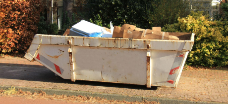
Building waste
All applications for development which include demolition or construction, must be accompanied by a Waste Management Plan and satisfy Council’s Waste Management Guidelines.
Sites can save substantially on tipping prices by separating waste loads for recycling. Compare the cost difference in the pricing table at Kimbriki.
Storage of materials and site access
From time to time building sites will need materials delivered that cannot fit on the site or need to access the site across public land. Building sites must obtain a separate permit from Council to use public land for this purpose if it is safe to do so.
Tree and heritage protection
Some trees or older items may be removed as part of a development consent but any that are to be retained are required to be protected to prevent accidental damage. This may include barricades and signage. To see items of heritage visit the Search heritage database.
Biodiversity Assessments
For some developments a Flora and Fauna Assessment (FFA) or Biodiversity Development Assessment Report (BDAR) may be required. Applicant guidelines are available to help you determine the biodiversity assessment requirements for your proposal.
Flood information
If you’re planning to develop in an area that’s subject to flood risk, you’ll need to consider how your development can be designed to manage flood risk and reduce the impact of flooding. Development must comply with the Local Environment Plan, the Development Control Plan, the Water Management for Development Policy, and if it is in the Warriewood Urban Land Release area, with the Warriewood Valley Water Management Specification.
Guidelines for development on Flood Prone land are available to assist in preparing a DA.
Bush Fire Assessment Report
All development on bush fire prone land will require a Bush Fire Risk Assessment and certification prepared by a suitably qualified consultant. A Bush Fire Risk Assessment and certification is required irrespective of whether the Bush Fire Prone Land map fully or partially covers the subject property. The NSW RFS provides further on Planning for Bush Fire Protection.
Waterways Impact Statement
Guidelines have been prepared to assist you to prepare a Waterways Impact Statement for your development.
Coastal Management State Environment Planning Policy 2018
Development proposals in coastal locations may be in areas covered by the Coastal Management Act 2016 and the Coastal Management State Environmental Planning Policy (Coastal Management SEPP), which came into force on 3 April 2018. See Planning NSW for online map and further information.
The Coastal Management Act 2016 defines the coastal zone as four coastal management areas, while the Coastal Management SEPP specifies how development proposals are to be assessed if they fall within the coastal zone. Each area has different characteristics and may at times overlap. The four coastal management areas are:
- Coastal wetlands and littoral rainforests area - areas which display the characteristics of coastal wetlands or littoral rainforests
- Coastal vulnerability area - areas subject to coastal hazards such as coastal erosion and tidal inundation
- Coastal environment area - areas that are characterised by natural coastal features such as beaches, rock platforms, coastal lakes and lagoons and undeveloped headlands. Marine and estuarine waters are also included.
- Coastal use area - land adjacent to coastal waters, estuaries and coastal lakes and lagoons.
A new Council Assessment Report is being drafted for further guidance. In the interim, an application must address the requirements of both the Coastal Management Act 2016 and the Coastal Management SEPP with reference to the requirements of development in the appropriate area(s).
Depending on the likely impact(s), it may be appropriate for these matters to be addressed within the Statement of Environmental Effects, although additional information prepared by appropriately qualified practitioners may be required.
Sydney Regional Environmental Plan (Sydney Harbour Catchment) 2005
Sydney Harbour Regional Environmental Plan (SREP) applies to the hydrological catchment of the harbour. It defines and contains specific provisions for the ‘Foreshores and Waterways Area’, strategic foreshore sites, heritage items and wetlands protection areas.
An SREP Assessment is required for any development works located within or partially within the delineated ‘Foreshore Area and Boundary’ line specified on the SREP Foreshores and Waterways map as per the requirements of the Sydney Regional Environmental Plan (Sydney Harbour Catchment) 2005.
All relevant criteria associated with the development works must be addressed when completing an SREP Assessment.
Where properties are tagged by both the Coastal Management SEPP and the SREP, the SREP holds precedent.
Download the SREP Assessment Template.
Water Sensitive Urban Design
The WSUD Technical Guide & Music Modelling guideline will provide you with information to assist you to develop a Water Sensitive Urban Design Strategy for your development. The Water Management for Development Policy also has information on stormwater quality requirements and stormwater management.
Documents
Useful links
- Development on flood prone land
- Flood Hazard Map
- Hazard Map
- NSW Environment and Heritage
- NSW Planning and Environment
- SafeWork NSW
- Kimbriki
- NSW State Emergency Service
- Property Search
- Permits
- Certification of building works
- Engineering specifications
- Water Management for Development Policy
- Flood Information Report Application
- NSW Guidelines for Erosion and Sediment Control on Building Sites