In celebration of World Environment Day, we are exploring the history of Warriewood Wetlands.
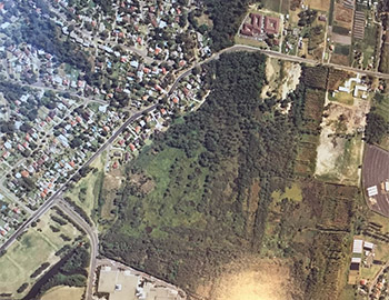
If you weren’t aware, Warriewood Wetlands is the largest remaining low-lying freshwater sand plain ecosystem in the northern Sydney area, at 26 hectares. The wetlands contain several rare and endangered ecological communities and plays a vital role in flood mitigation, nutrient recycling and filtering sediments.
Indigenous Heritage
It is likely that First Nations people would have occupied the margins of the Warriewood Wetlands, on ground that was sufficiently elevated above the wetlands to provide a dry campsite. The wetlands may have provided many food resources such as waterbirds, fish, eels and yabbies. Unfortunately, any occupation middens are unlikely to have survived the impact of very intensive rural development in the Warriewood Valley.
European Settlement
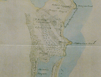
The first settler, James Jenkins, was granted 350 acres at Warriewood and by 1829 had established Cabbage Tree Hill farm, named after the Cabbage-Tree Palms (Livistona Australia) growing on the property. The earliest map of Warriewood Wetlands is shown as “Narrabeen Swamp” which runs from the northern shore of Narrabeen Lagoon to the north-west, marked with a sedge symbol on the map. No land was granted in the swamp area at the time of the creation of the map however there are land grants to the west, north and east of the swamp.
Naming of Warriewood
In 1892, Edward Augustus Macpherson named his farm “Wharriewood”. He was of Scottish descent and “Wharrie” is a family Gaelic middle name meaning “Noble”. His father was Joseph Wharrie MacPherson Snr. and his younger brothers were Joseph Wharrie Macpherson Jnr. and Septimus Wharrie MacPherson. Through the years, the suburb became known as Warriewood.
Agricultural Development
During the 1920s, new settlers came to Warriewood including several families from former Yugoslavia. The area expanded as a farming district and was known as Glass City because the valley was covered with approximately 3,500 glasshouses, mainly used for cultivating tomatoes.
Production reached its peak between 1947 and 1954 but as the 1960s came, market gardening declined and some land was redeployed for nursery production. Most of Warriewood, apart from some pockets of light industry, was zoned as a rural area until 1991 when the State Government permitted subdivision. By 2000, the rural character of Warriewood began to change as the valley became a residential suburb.
The fight to save Warriewood Wetlands
In the late 1970's, the New South Wales Government agreed to let developers build a shopping centre on part of the site under the condition that Warringah Council would purchase the remainder of the site for retention as a natural area. Dispute over what constituted a fair price for the area continued until 1996 when, following an 18 year-long battle by conservationists, the matter was resolved in an out of court settlement which resulted in the purchase of the land by Pittwater Council for $4.5 million.
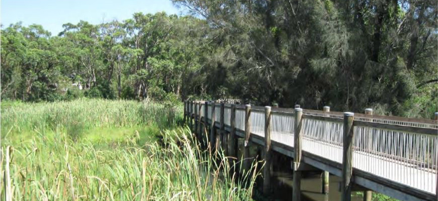
Warriewood Wetlands is now a popular family walk about 2.4 kilometres long. It is a fantastic public green space as well as a rare example of a wetland ecological community in the middle of a large city.
The walking trail is flat and shaded, with long boardwalks over the wetland areas. Don’t forget though, dogs and bicycles are not allowed. If you watch and listen, there are over 80 species of birds and other animals such as lizards and frogs to experience.