Will the Draft Structure Plan have a legal effect on what I can do on my property? Can I still lodge a development application in the meantime?
At this stage the Draft Structure Plan does not change the zoning of land and landowners can continue to use their land in accordance with the current zoning and current planning rules.
It is important to be aware however, that as part of the exhibition package, amendments to the State planning document SEPP (Sydney Region Growth Centres) 2006 are being proposed. This has the effect of designating Ingleside as a Priority Growth Area and has implications in terms of the assessment of current and future development applications located within the Ingleside area. If you have questions relating to this, you are able to contact the Department of Planning and Environment by calling 1300 305695 or by email at community@planning.nsw.gov.au.
The Draft Structure Plan proposes future land uses for all parcels of land within the Ingleside Precinct and will ultimately inform the future zoning of the land. Once the land is rezoned there may be changes to what can legally be undertaken and for this reason, you are encouraged to participate in the consultation process.
What kind of development will come as a result of the land release?
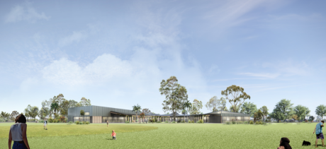
A residential community with a defined conservation area serviced by a range of community facilities/services is anticipated for the Ingleside Precinct. A variety of housing types is anticipated, ranging from standalone homes on large lots to a range of different-sized allotments, attached and semi-detached housing such as terraces, townhouses and residential units in low-rise residential flat building and shop-top housing developments. In some instances, the character of a particular area may not change significantly, but in others, housing densities are likely to increase.
What are the anticipated residential densities across Ingleside?
Future residential densities across Ingleside will be investigated through the precinct planning process. The consultants’ investigation reports are currently available to view and have informed the decisions made so far about the appropriate residential densities that will apply. The detailed provisions of the actual proposed residential densities will be exhibited during the formal statutory exhibition of the Planning Instrument and Development Control Plan.
Will the government encourage and facilitate those sites where owners have pooled land for development?
The planning agencies, in this case the Department of Planning and Environment and Northern Beaches Council, encourage land-holders to pool land for future development proposals. This approach can facilitate the installation of services, infrastructure and design of new subdivisions by developers.
Will amalgamated sites be dealt with as a priority?
The Structure Plan can be more effectively realised when owners pool their land. In considering and approving development proposals across the precinct, Council will be guided by the Structure Plan. Priority is more likely to depend on the availability of service infrastructure to different parts of the precinct and on developers to make the necessary arrangements to service their proposed developments. Where land is amalgamated and there is clear evidence of an intent to develop, infrastructure agencies are able to make investment decisions with less risk. In this regard, amalgamated sites can facilitate early development.
Can groups such as the Wilga Wilson Residents Association prepare a master plan for their site and present it to the Ingleside Community Reference Group (ICRG) for comment and approval?
In agreeing to progress the planning for Ingleside, the Minister for Planning clearly articulated that the planning investigations of, and future development, in Ingleside should consider the Precinct as a whole. Consequently, the planning process will produce a Structure Plan for the Ingleside Precinct. The Wilga Wilson area is an integral part of this precinct and we are interested in the Association’s views about future development in this area. It is always helpful to understand the intentions of developers when preparing the Precinct Plan, but our approach remains to deal with the entire Precinct in a coordinated way. The Association could present ideas for their land to the Department, Council and UrbanGrowth NSW. We will consider any representations and will incorporate information from submissions into the overall Precinct Plan as relevant and appropriate. However, we will not provide any endorsement or approval of site-specific plans during the precinct planning process.
The ICRG is a forum for providing feedback to Council and the Department on the planning investigations. The ICRG does not have an approval role for any aspect of this project. It is therefore not appropriate that you seek endorsement of your plans from the ICRG. The Terms of Reference for the ICRG clearly set out the role and functions of the ICRG.
Will new development include affordable housing for key workers?
The Greater Sydney Commission is currently exhibiting the District Plan for the North Region which includes a target of between 5 percent and 10percent of new floor space being designated for affordable housing at the point of rezoning the land. it is anticipated that development in the Ingleside Precinct will meet or exceed the target specified by the Greater Sydney Commission.
 |  |  |