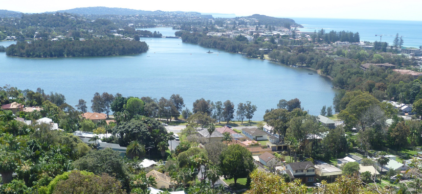
Council often receives enquiries about how we manage Narrabeen Lagoon. It is the largest lagoon in metropolitan Sydney with a catchment bounded by Warringah Road, Forest Way and Mona Vale Road. The lower part of the catchment, particularly around the lagoon, can flood whether the entrance is open or closed. Below are some brief questions outlining why and how Council manages the entrance of the lagoon.
Why does Council open the entrance at Narrabeen Lagoon?
Lagoon entrances will open and close naturally depending on how much rainfall has occurred and how much sand has accumulated in the mouth. Council opens the entrance of the lagoon when water levels rise and reach specific levels, this allows water to drain from the lagoon and helps maintain an open lagoon entrance. The two separate ways that Council open the entrance are described further below.
When and how does Council open Narrabeen lagoon?
Council opens the lagoon in one of two ways:
- Sand Clearance: When there are very large accumulations of sand both in front of Ocean St bridge and in front the Caravan Park, the entrance will often close and stay closed until the sand is removed and placed on Collaroy-Narrabeen Beach. Historically, this process happens every 3-5 years, with the last one being completed at the end of 2021. The timing of the works is based on the amount of sand in those two locations and if it accumulates more or less than anticipated, Council will change the timing of the works. Following the adoption of the Narrabeen Lagoon Entrance Management Strategy (2022), Council will trial more frequent but smaller sand clearance operations. .
- Channel Opening: In between these big projects, the entrance will usually stay open as long as there is regular rainfall and/or no build-up of sand into the mouth of the entrance. If it closes and doesn’t need a sand clearance, Council can dig a short channel at the entrance when the water level in the lagoon gets above 1.3 metres above sea level. While it can be opened slightly lower (between 1m and 1.3m), this will only work with significant outflow from the lagoon (eg with a lot of rainfall). If the water level is not high enough, it won’t flow down to the ocean fast enough to clear sand and stay open beyond the next tide.
How does Council monitor rainfall and water levels?
Council monitors the water level and lagoon entrance conditions through site inspections and digital water level recorders, which are publicly available at Northern Beaches Flood Information Network. We also monitor rainfall through that website along with advice from the Bureau of Meteorology, and Manly Hydraulics Laboratory at Manly Vale.
You can find more information about Narrabeen and other lagoon opening triggers, and a more extensive list of FAQs on our Lagoons page.